
Share this page!

Custom Search
|
Click here to select another year
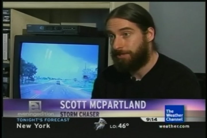
March 20th, 2008---: After a long, but not so brutal Winter, Spring is finally here!! Plans and preparations are underway for this years storm chasing trip, and it won't be long now until we are on our way. To start Spring off, I lended my advice to The Weather Channel for their Tornado Prepardness Week, and last night they ran my segment...below is a screen cap from that segment. We talked about tornado safety and overall I was happy with the way things turned out. Check back often as this page is going to be updated on a regular basis. I plan to update a lot more this year than in the past.
April 6th, 2008---: Dave and I are keeping an eye on this next trough moving into the plains around the mid week timeframe. Right now the timing doesn't look that great, and moisture return might be a problem for Wednesday, but we have about another 36 hours to ponder over model runs before we have to make a decision. We did go ahead and booked a flight out on Tuesday evening to Denver on Jet Blue, and a return flight on Sunday the 13th. Why to Denver? Well, Jet Blue had very reasonable airfares unlike all the other airlines at the last minute, but.....the downside is Denver was the closest "mid west" city we had the choice of flying into. The problem with that is this...would we be able to make it to the target area on Wednesday if that ends up being down in northern/central Texas, and if not...will the moisture make it up into the Oklahoma region making for better chase prospects up there. Oklahoma would be easier for us to reach starting from Denver than north/central Texas would be.
Aside from all of this, any chase prospects on Thursday right now look to be pretty far to the east in less than desireable chasing terrain. Chasing in the hills and trees of Arkansas isn't very appealing, lol. I dunno, we have some more time to ponder over things before having to make a decision. The nice thing is that if we do decide to cancel, we will be given a credit that will be good for up to one year on Jet Blue. Dave and I have no doubt that we'll use that credit either later this month, or in June. Let's not forget that our annual May chase trip is coming up FAST! Either way, it won't be long now until we're out there doing what we love to do! More updates following soon...
April 10th, 2008---: Well, Dave and I decided to hold back on our planned trip for this week. And, so far it seems that we made the right choice! While there were some interesting storms and a few tornado reports in Texas yesterday, it would have been extreamly difficult to drive all the way to Abilene, TX from Denver, CO the night before. We would have had to drive all night to make it there for initiation, and even then....who's to say we would have gotten on the one storm of the day. That storm produced a brief tornado near the town of Breckenridge, TX. Many chasers were on the storm and reported a rain wrapped tornado briefly on the ground. There were also reports of tornadoes in Oklahoma as well, but several were after dark. Today looks to be one giant mess in Arkansas and Missouri with fast storm motions, horrible terrain, and tons of rain....Oh, I'm sure they'll be many many severe weather reports, and even some tornado reports, but this isn't a dream type set up for storm chasers.
Dave and I have a credit with Jet Blue that's good for a year, and I'm sure it won't take a year for us to use that credit! More than likely we'll be using it within the next few months. We feel pretty confident that we can pick a much better set up to use this credit on! Stay tuned as chase 2008 preparations continue!.....
April 21st, 2008---: Our 2008 chase trip is rapidly approaching once again! Yesterday, I met Dave in East Fishkill, NY at our friend Marc's house to do our yearly hail guard maintenence. But this year we also needed to test fit our new "roof cam"! Both Dave and I are incredibly excited to try this out in some hail. Not huge hail, lol...but golfball size would be nice. After we completed inspecting the windshield hail guard for any cracks or broken welds, we bolted it onto my roof rails, and then proceeded to replace my old car battery with a brand new Die Hard! Then we replaced a few parts on the Lexan hail guards, ate some lunch, and then did a little go-carting to round out the day! I've posted some pictures on our "New Photos" page, be sure to check them out! If all goes to plan, we could be on the road within 10 days (weather permitting of course) More updates coming soon...
April 22nd, 2008---: For the time being at least, it looks as if the first few days of May will not be conducive for severe weather. The ECMWF model is currently forecasting a huge trough in the east with a plunging cold front making it's way all the way to the Gulf Of Mexico. If that verifies, there goes our moisture/heat source..lol. The other medium range model (the GFS) paints a bit of a different picture so right now it's not too clear as too exactly what will happen, but as is always the case, we'll be keeping an eye on things. It could turn in the other direction in a heartbeat. Either way, Dave and I will be on standby to leave anytime from May 1st onward!
Now on to our hail guard designs for my Xterra. I've been asked many times exactly what they look like, how they were made, etc. Well, Dave has posted a very in depth explanation as to the in's and out's of it all. Starting from the basic ideas, to the construction, to the finished guards. Click on the link below to be taken directly to Dave's hailguard explanation page!
Hail Guard Explanation & Photos
April 28th, 2008---: Without jinxing it, things are starting to look pretty interesting for the early part of May! There could be a good set up out on the plains this coming Thursday the 1st, but Dave and I cannot leave until the 1st so there's no way we'd make that. But, if the various models are correct, then we may be entering an active period come May 3rd or so, and that we CAN be there for! For now, we're tentatively planning on leaving Friday afternoon or Saturday morning. For once it's starting to look like we may be able to take our time getting out there instead of having to do the marathon drives of seasons past.
We'll make the final decision on whether to pull the trigger or not on the trip by Tuesday/Wednesday of this week. In any event, my chase preparations are continuing on as planned and I'll have everything in place by Wednesday in case we need to head out on the road by weeks end. Check back for more updates tomorrow!
May 3rd, 2008---: Dave and I have decided to pull the trigger on our trip this afternoon! Lots to do in the next three hours. I'll be leaving here around 1pm and will drive up to Fishkill, NY where I'll pick up Dave and we'll start heading west. We're hoping to make it to eastern Ohio tonight where we'll set up for the evening. Tomorrow we'll be meeting up with Mark Robinson somewhere in Ohio most likely. More soon!!
May 4th, 2008---: We stopped last night in Washington, PA after a solid 8 hours of driving yesterday afternoon/evening. Washington, PA is located in the extreme western part of the state and we'll be heading on westward in about a hour towards the plains. Right now there is a good chance of storms in western Kansas tomorrow evening, and we want to make it there in time. Tuesday and Wednesday also hold some promise and we're also keeping our fingers crossed that this secondary trough that some of the forecast models are predicting will actually materialize. Today we'll be covering a lot of road and we're hoping to be in Missouri by this evening. More to come!
May 5th, 2008---: Dave and I just pulled into Amarillo, TX about 10 minutes ago. It's now midnight and we started the day in Lawrence, KS. Man oh man did we drive A LOT today! We played around in a storm just north of Woodward, OK this afternoon and shot video of some nice pea size hail, lightning, etc. Setting up here in Amarillo for the night in hopes of an interesting day tomorrow. Tomorrow we'll be hooking up with Jim Edds, Jim Leonard and Michael Laca! Stay tuned!
May 8th, 2008---: Dave and I are here at the Guest Inn in Norman, OK. It's been about 3 years since I've stayed here and it's nice to be back! The Guest Inn in a popular stop for many chasers heading through the area! Jim Edds, Jim Leonard and Michael Laca have headed home for the time being but Dave and I are hopeful that things will pan out for next week. Right now the models disagree on the severe weather threat for next week. The GFS paints a nice picture, the Euro paints a bleak picture. We'll be keeping our fingers crossed. For today, Dave and myself along with Mark Robinson and Dave Suddaby will be heading into Western, KS for the possibility of some elevated supercells popping up there later this afternoon. The tornado threat is minimal, but we'll be happy with some nice structure shots, some hail and some lightning! I'll keep you posted!! One more note about yesterday. We stopped for data in Greensville, TX and wow what a chaser convergence there was there!! Everyone from Charles Edwards and Cloud 9 Tours, to Reed Timmer were there! We chased in the northeast Tx, southeastern OK area but to no avail. All the storms quickly lined out and we decided to call it a day and head north to get into position for the possible Kansas storms today.
May 8th, 2008---: The day began with a slight risk for western Kansas. We decided to go for it and were certainly glad we did! While there were no tornadoes sighted, we did see just about everything else a Great Plains Supercell had to offer. We left Norman, Ok around 11am and headed east on I-40 and then northward on the 183 towards Woodward, Ok. We were heading towards the Dodge City, KS area when we noticed that a few storms had already begun to explode near Garden City, and points north. We blasted west on the 54/400 out of Dodge City and intercepted the southern most cell. This storm really really tried to put one down! It had everything! A massive hook echo appeared on radar and it was very clear to all of us that the storm had a lot of rotation to it! We filmed some great structure, and continued to hope that it would put one down since it was over completely open land, but it just couldn't do it. Actually, it had put a tornado down before we were able to get to it, but still...no complaints from me! This was more than all of us had hoped for today. We also had the crew from Pioneer Productions in tow with us as well today so it was nice that they got to see something too. Got a lot of great shots today. Below is the radar image I was referring too..just look at that hook!! Tomorrow is a down day so we'll be doing a bunch of filming with Pioneer for Raging Planet 2....Saturday looks like the next chance of storms.

May 11th, 2008---: Storms were around yesterday, but we honestly didn't see much due to the horrible roads and terrain. Most chasers did have this kind of luck, but there were a select few that got on the storm in northeast Oklahoma that produced the damaging tornado there. Unfortunately there were many fatalities from this particular storm. Something we never like hearing about. Our thoughts go out to everyone affected by this storm. Today is a travel day and tomorrow we could be back in western Kansas chasing! Then Tuesday could be in Oklahoma once again, and finally....Wednesday in north/central Texas. After that three day stretch, it's back home to NYC! More updates to come!!
May 12th, 2008---: We stayed in Enid, OK last night in the hopes that a potential western Kansas target would verify. When we awoke this morning at the Days Inn, we quickly realized that this was not going to happen. So, we decided to head back down the I-35 towards Norman, OK and we're here again at the Guest Inn. There are two possible targets for tomorrow, and both are not too far from this area. We're hoping that we at least get to see some interesting weather tomorrow, especially after the extreamly frustrating chase on Saturday in the jungles of southeast Oklahoma/southwest Arkansas. Stay tuned!!!
May 15th, 2008---: Yesterday we got on some great storms near San Angelo, TX. We first encountered a nice LP Supercell and got some great shots of that, but soon our attention was turned to the southern cell which was rapidly taking over. That storm turned into an HP monster with the most incredible, and insanely close lightning strikes I've ever witnessed!! At one point we were almost struck while taking shots on the side of the road. The bolt hit just across the road and for a brief second, I thought we were done for. It really did scare the you know what out of me, and we all quickly jumped back into our vehicles. That was it as far as getting out of the cars went until we were far enough away from the storm and felt relatively safe again. Rotation was clearly visible on this storm and right as we got to the town of Brady, TX.....the hook wrapped in on us. I saw the rain curtains rotating right in front of us and at that point we figured we were going to get into some sideways flying baseballs! lol...Turned out there wasn't any hail in the hook, but damage was being done all around us as we drove through the town and we really did want to get out of there as far as possible. If this storm had a tornado at that moment, it would have been pretty close to us. We stopped a few more times but eventually the storm pulled away from us, but not before we managed to grab some more great shots! Today our chase trip ends, and we begin the LONG drive back to NYC. We should be back home by Saturday, and I'll be sure to post many pictures, and video clips next week. Check back for those!
May 21st, 2008---: Our 2008 main storm chase trip has been completed and I'm in the process of editing up all the video I shot while out on the road. We managed to get on some decent storms while we were out there so overall this years trip went rather well. However, a potentially active period out on the plains is imminent and unfortunately Dave and I can't be out there this time around. The timing is just bad for us since we have some obligations here. We needed at least a week or so between our main trip, and our spot chase where we fly out and rent and this time around things just aren't panning out in our favor. Best of luck however to all those who are able to chase these next few days! Dave and I will be ready to head back out for a few days anytime after May 27th. When the next multi day set up comes along, we'll be there! Check back as I'll be posting some video soon!
June 3rd, 2008---: After much thought, and stress.....Dave and I have decided to pull the trigger on our 2008 spot chase. We fly out this evening to Denver and will do our best to make some headway tonight before stopping and getting some rest. Tomorrow and Thursday definitely hold potential, but there are some major concerns. A strong cap and possible veered 850 flow are the two main ones. But, overall many of the parameters are in place for what could be an interesting few days. Saturday also holds potential as well, as does Sunday. Our plan right now is to fly back to New York this coming Sunday the 8th. If we see that Sunday looks like an outbreak day, we'll most likely stay and fly home on Monday in that case. Check back as I will be updating as often as possible from the road!
June 5th, 2008---: Dave and I flew out on Jet Blue to Denver on Tuesday evening and we arrived around 10:45 local time. We grabbed our rental car and headed off to Limon, CO where we'd hold up for the night. We got into Limon around 1am so needless to say, we were BEAT! We got about 6 hours of sleep and then headed out early the next morning to our target area of south eastern Nebraska. We hooked up with Charles Edwards and Cloud 9 Tours and thus began our chase! We did intercept some nice cells in and around Kearney, NE but it was pretty clear that we weren't going to be any tornadoes. Still though, we managed to get some nice video regardless and overall were happy with the day. But, what we didn't know was that soon....things would get really interesting!
Around 11:30pm I heard a knock at our hotel door and it was Charles Edwards saying that Kearney was under a tornado warning. I thought he was joking initially, but soon realized that he was not kidding after looking at the radar. Just to our west was a nasty cell just about to over take us. At that point I began to hear quarter size hail hitting the ground outside and I knew that we had to move fast. I woke Dave up and then quickly grabbed my video camera and car keys and hauled it out the door and down the hallway. I ran outside and jumped in the car in the hopes of finding some shelter so we didn't lose all our glass. As luck would have it, there was a Casey's General Store right next to the hotel, and attached to the store was a gas station with an overhang! I raced over there and pulled up under the overhang where I found another car sitting there awaiting the storm.
Within seconds the hail began to fall and this time...it was bigger! It was a golfball barrage with some rouge tennis ball size hail in there for good measure, lol. With the extreme winds that were now blowing, the smaller hail stones were sneaking in under the overhang and nailing our rental car. I was rolling video through all of this and I got some great shots of the bigger stones smashing into the puddles and in turn ejecting water up off the ground a good two to three feet in the air! It was insane, and VERY loud! Dave was holding up in the hotel rolling video from our room. I haven't seen it yet but from what he tells me, he was sure the glass was going to shatter in. Things wound down after about 10 minutes and then we all shared our stories and then, finally....settled in for the night. Upon waking up this morning and accessing the damage, we realized that many cars in the hotel parking lot, as well as the hotel itself sustained damage. The owner of the hotel lost her side glass, and several rooms in our hotel had also lost glass. A car dealership next door also suffered major damage to several of the vehicles that were out in the open lot. All in all, it was a VERY interesting way to end our first day chasing. Our second day however would not be as interesting.
Today was a high risk and we really didn't see much of anything, lol. Basically after some discrete storms early on, everything congealed and now there is a raging squall line that takes up about 5 states going on right now. Tomorrow holds some hope in southeast Kansas/northeast Oklahoma so we'll see what we can get! We are not going to chase Illinois, but instead will play the southern end of things. Stay tuned! More updates to follow!
June 10th, 2008---: Our 2008 spot chase ended on a high note! Actually...the last two days of our trip (June 6th & 7th) were very eventful! On June 6th we were with Cloud 9 Tours and Chris Kridler somewhere in extreme northeastern Oklahoma, near the town of Claremore. It was 6pm and it just didn't look good at all so we decided to call it and started to head back north in the hopes of making it as far north into Kansas as possible to set up for the next day's chase. We noticed that the surrounding storms had taken on a more appealing look so we decided to pull off the road and get some video. From there, it was all uphill! One of the storms had taken on supercell characteristics so a very important decision had to be made.....do we chase this even though on radar it didn't look very good at all, or do we say forget it and continue on north as planned. Well, thank god we decided to go for it because what we had on our hands was a nice structured LP Supercell. LP storms have poor radar presentations due to the fact that they do not carry a lot of precipitation with them, therefore they do not show up on radar too well. We got on the storm and it just looked better and better as time went on. It even developed a wonderful tail cloud and adjacent wall cloud that for a while there, we thought might put down a tube! It didn't in the end, but it did produce a pair of "kissing funnels" as I like to call them. Basically two horizontal vorticies connected with eachother under the wall cloud, it was the most crazy thing I'd ever seen and apparently, pretty rare to boot! The setting sun lit up this storm in gold, yellow and pink near the town of Pittsburg, KS...truly amazing to see and a great way to end our next to last chase day..the following day would be even more interesting!! Read on.....
We started the day in Fort Scott, KS where we agreed that our target area for that day would be somewhere in either south central Nebraska, or north central Kansas. We headed out around 10am and much to our surprise, Chris Kridler (who was set to fly out that afternoon) decided to hang around one more day and chase with us! A great surprise and well worth it in the end. We headed up route 69 in extreme eastern Kansas and while cruising along, we had a 2002 or 2003 Black Camaro pass us on the shoulder moving at around 120 mph, no I'm not kidding...lol, and right after that a cop car went flying by. It was a high speed chase!! WOW, I've never seen that before. Anyway, back to the chase. We arrived in Beatrice, NE around 3pm and spoke with Charles Edwards of Cloud 9 Tours. We discussed the days target and Charles informed us that there were some cells going up in Kansas to our southwest...maybe about 85 miles away. At this point however I have to admit, I wasn't too excited due to the fact that they looked pretty linear and I figured that was it for the day...we're going to have a raging squall line. Well, it didn't work out that way. The line never fully formed, or I should say...never unzipped all the way down into southern Kansas. Instead the storms just kept rebuilding over the same area. We decided to head down that way and investigate. Basically there were three storms we were interested in towards the southern end of this line. We investigated the northern storm first and that one looked okay, but a bit too high based for our liking. Still though, we managed some great photo ops before deciding to move on to the middle storm. That storm was located near the town of Jewell, KS. Jewell had actually been hit by an EF3 tornado just two weeks before, so it was a sight to see a supercell and wall cloud in the background with the still fresh tornado damage in the foreground. After about 30 minutes of grabbing video and stills from that location (and getting eaten alive by musquitos) we decided to investigate the southern most cell. This cell had now become dominant and WOW....what an amazing storm this was!!! As we got closer we could see the classic UFO/Mothership appearance this storm had. I was in awe and couldn't wait to get closer and we all felt that this storm had the best shot at producing a tornado. We passed the town of Cawker City, KS (where the world's largest ball of twine is located) and then through the town of Downs, KS where by now..the base of the supercell was clearly visible. We decided to pull off at the intersection of route 281. We could hear the hail roar from this storm and knew that we had to proceed with caution. We shot video for a while and the entire time we could see the base rotating and the wall cloud which was now visible to our west had a classic look to it. Right as we decided to reposition a bit further east a funnel became visible and about a mile down the road, we pulled back over and set up our cameras in anticipation...this was it!! The wall cloud was now just to our north and spinning like a top!! After about a minute of shooting video we could see that a tiny pencil like funnel was forming and before long, it touched down and we had a tornado!! It was brief and small, but it was a tornado none the less and needless to say....we were all very excited! We decided to follow this storm after the sun set since it still had an amazing radar presentation on it, but it did not go on to produce another tornado. Well, not any that we saw at least..but there were some ominous funnel like clouds that we witnessed right at twilight. An amazing day overall and a nice way to end our 2008 spot chase! We started the long drive back to Colby, KS where we set up for the night...got about 4 hours of sleep and then drove back to Denver to catch our flight home. Wheew!!! What a trip!! Below are two radar images. The first one was of the surprise LP supercell near Pittsburg, KS on June 6th, and the second image was of the massive tornadic supercell near Downs, KS on June 7th (look at the hook on that one!!)


July 23rd, 2008---: Here we are at the height of Summer and the tropics have started off with a bang! Hurricane Dolly is making land fall as I type this near the Texas/Mexico border as a Category two hurricane. This was the one week that I could not chase due to the fact that our yearly summer vacation starts this Friday. Cecelia and I are heading to the desert southwest! We'll spend a few days in Vegas with my friend Jeff, then it's off to the Grand Canyon for a day, and then we'll try our hand at some lightning chasing in and around Phoenix for a day or two before returning home the following Friday. Even if I wasn't going anywhere this Friday, I would have still passed on intercepting Dolly. To travel all the way down to practically the Mexican border for a Cat 2 hurricane would not have been worth it. That entire area down there is pretty desolate to begin with, nothing really in the way of shelters at all! I will post pictures upon my return so be sure to check back for those!
August 8th, 2008---: Cecelia and I have returned from our desert southwest trip and what a great time we had! Storms were sparse since the three days we were able to chase happened to be the three days that everything shut down. But, we still managed to get a few storms and the ones we did get were beautiful! We also spent a few days in Vegas with my friend Jeff, and also got to check out the Grand Canyon, Meteor Crater, Lake Havasu and the London Bridge...and finally, Phoenix. Photos are now up on my "New Photos" page, check them out! Next up on the list will be the hurricane season which should be ramping up soon now that we're into August. More to come!!
August 15th, 2008---: The tropics are coming alive, and we are watching closely as invest 92L moves towards Puerto Rico and Haiti! As I type this, 92L has not been classified a tropical depression by the NHC, but this could change at any moment. However, it's close proximity to land will most likely inhibit it from strengthening rapidly at least for the next 24 hours or so. It is getting better organized however, and it is a threat to the US so we need to keep a watchful eye for sure! Right now, the model guidance is having a tough time of things undoubtably due to the fact that it's a weak system, and more importantly....no one is really sure where the low center is exactly. If and when the system strengthens, the models should get a better handle on the possible track. Until then, we'll keep watching hour by hour! Stay tuned!
August 26th, 2008---: Oh wow, that sums it up. Invest 94L went from a tropical disturbance to a Category One Hurricane in 24 hours and Gustav is not done by a long shot! More strengthening is forecast for the next few days and as of right now, the forecast track takes him into the Gulf Of Mexico over the weekend! Many things can and will happen between now and then, but needless to say....we're all keeping a watchful eye on Gustav. Dave and I would intercept this storm if he threatens the US, and our friends Mark Robison and George Kourounis from Toronto would be joining us as well. Initial preparations are underway and I'll have another update tomorrow so check back!
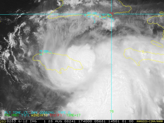
August 28th, 2008---: What an eventful last two days it has been! Things still look on target for intercepting Gustav somewhere along the gulf coast early next week, where exactly is still anyone's guess. After pounding the coast of Haiti for a solid 24 hours or so, Gustav has finally moved away from that island, and after it's center reformed further to the south, he now has his eyes on Jamaica! He was almost torn to shreds last night by the tall mountains on Haiti's southwest coast, but we all were amazed at how fast he recovered this morning. There's little doubt that Gus will weaken somewhat as he traverses Jamaica, but I don't think it'll be that much. And, once back out over the open waters, he'll have the highest ocean heat content still ahead of him, not to mention an upper level anti-cyclone sitting on top of him. Many questions still remain but Dave and I have to commit by tomorrow for a Sunday flight out of NY. Stay tuned!! Below is a shot taken just a short while ago of Gustav as he approaches Jamaica.
September 3rd, 2008---: Dave and I did end up taking the plunge and we intercepted Hurricane Gustav in the town of Houma, LA. Things happened so fast I didn't even have time to update this page prior to leaving. Anyway, here's how it all went. Dave and I flew out of JFK this past Sunday the 31st and we landed in Jacksonville, FL around 4pm. Jacksonville was the closest airport we could get that wasn't going to be in the affected zone. Then, after getting the rental car we drove the 650 miles to our target area and met up with George Kourounis and Mark Robinson from Canada....as well as Tim Millar from Florida. But, getting to the target area meant driving through New Orleans at 2am when a curfew was in full affect. We both kept our fingers crossed and after getting turned around a few times by road blocks, we made it across the lake, and into Houma where we finally arrived at 3am! After arriving and greeting all our chaser friends who made it there before us, it was time to grab a quick nap before things started to pick up. We logged a righteous 1 hour of sleep before having to get up and get ready, lol
The show started around 6am and by 9am, we were receiving sustained winds in the tropical storm force range. This was by no means the predicted doomsday scenaio by any means, but Gustav did put on a good show for us when all was said and done. We documented the northern eyewall as it moved over Houma and were treated to a barrage of flying shingles, sheet metal, glass and tree parts. But, the real fun came when we were driving down Main street in the center of town and one of the above mentioned roof shingles came flying right through the passanger side window on our vehicle! Thankfully neither Dave nor I were injured, but now we have a problem.....no glass on the passanger side! We quickly retreated to the parking garage (which by the way was the same garage where the local police were housing their vehicles as well) and we proceeded to clean up as much of the broken glass as possible. Mark thankfully had some thick plastic sheets that we afixed to the door and in the end, this did help keep most of the rain out of the vehicle when we decided to venture back outside. Notice though, I said "most" of the rain was kept out, lol. After getting our fill of Gustav, we all decided it was time to start making our way back east towards New Orleans and points further so we got on the road around 4pm. George, Mark and Tim had a room in New Orleans and Dave and I proceeded to Crestview, Fl where we had a warm bed awaiting us...god did that bed feel good!!! And then yesterday, we flew back to NY. Wheew!! In the past 72 hours Dave and I have flown over 2000 miles, driven over 1300 miles, chased a hurricane, and lost a side window. Talk about a fun filled few days eh?! Now our attention has once again turned to the tropics as more storms are churning away over the open waters. Stay tuned! Oh, and if you are interested, click the link below....George had a Dateline NBC crew with him and they chronicled our Gustav intercept. Dave and I make a quick camero appearance towards the end. I have the blue rain gear on, and Dave has the yellow rain gear on!
Dateline NBC Hurricane Gustav Segment
September 12th, 2008---: Dave and I decided against intercepting Hurricane Ike. The main reason was due to the fact that he will be coming ashore well after dark. It's very difficult to remain safe during night land falling hurricanes (been there, I know) and from a video standpoint, well....you just can't get much due to the lack of light. All the best to those who went after him though. While the winds aren't in the Cat 3/4 range, the storm surge is! I know of a few chasers that are on Galveston Island right now, the water is already rising there!
October 1st, 2008---: Ike is still in the news three weeks after he made land fall on Galveston Island and many folks are still unable to return to their homes. The damage in and around Galveston Island was pretty extreme and a DVD is in the works that will document Ike from birth, to land fall, to aftermath. While I am not directly involved in this production, I can tell you that it's sure to be a must see! Check back for more details..