

Share this page!

Custom Search
|
Click here to jump to my latest entry!
Or, click here to select another year
January 5th, 2010---: For the last few weeks we've been way below normal temperature wise, and this upcoming week and into the weekend will be no exception! We're averaging a good 10 degrees below normal, and by Friday morning, our daytime highs will only be in the low 20s! Night time temps will fall into the low teens, with single digits in the normally colder spots north and west of NYC. A storm system will move south and east of the area Thursday night, but as it appears right now, this low will pass too far south of us to bring any significant amount of snow to the area. However, I have a feeling that winter is just getting started, and it's only a matter of time before the next big nor'easter will be on our doorstep.
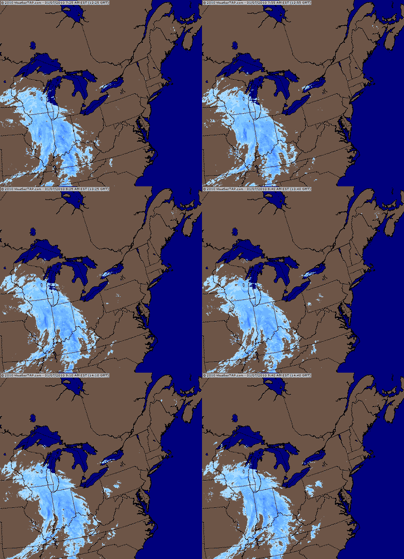
January 7th, 2010---: This winter is shaping up to be a doozy so far! We're only a few short weeks into the season and already we've seen one major snow storm, sub freezing temperatures, and now...an Alberta Clipper is on the way, and with it, more snows to the NYC area. As with most Alberta Clipper systems, we're not talking about heavy snow fall totals, but this system will bring with it one to three inches of snow by tomorrow afternoon. The bulk of the snow is forecast to fall between 3am and 9am tomorrow morning, insuring a hectic morning commute to work for many people. And this weekend is shaping up to be quite cold. Temperatures are forecast to hover in the mid 20s for the entire weekend, with morning lows in the teens! Below is a regional radar animation courtesy of WeatherTap showing this Alberta Clipper making a bee line for the northeast.
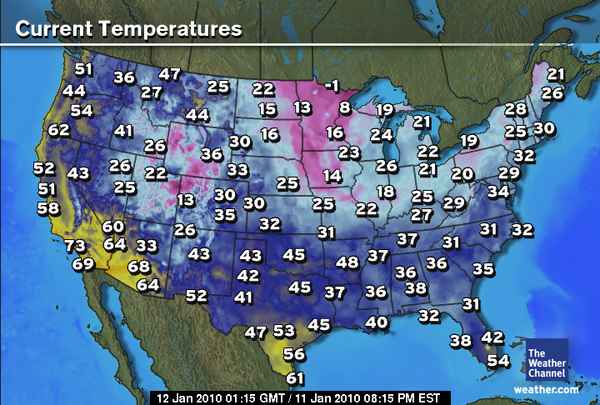
January 11th, 2010---: The past few days have been pretty brutal in terms of cold weather. Our morning lows have been dipping into the teens, with day time highs only reaching the 20s for the most part. Ughhh, this is not fun at all. But, as bad as it is here, that's nothing compared to how bad it's been in other parts of the country! Temps in the midwest have been dipping in many cases well below zero, and even the Florida Keys have gotten in on the action. Our good friend Jim Leonard who lives in the middle Keys reported a morning low yesterday of 38 degrees!! WOW, now that's something you don't see very often at all. As it stands right now it's looking like the cold will start to lose it's grip starting tomorrow and by late week, we might actually reach the 40s! WOW, a virtual heat wave, lol. There's some rumblings of a possible weekend storm, but it's way too early to pin anything down right now. More updates to come regarding that. In the meantime, just another 9 or 10 weeks until Spring! The map below shows the current temps as I type this. Low 50s in Miami???
January 19th, 2010---: After a very cold start to the new year, temperatures finally recovered this past week to in many cases, actually above normal! We saw several days in the 40s, and the past two days in a row we actually reached 50 degrees. However, there will be a trend downwards in the temperatures over the coming days, but nothing too terrible overall. A storm system now currently over California will reach our area by Friday. Right now however it appears that much, if not all of the precip associated with this storm will stay south of the area. Temperatures are forecast to remain in the upper 30s to near 40 degrees. Which in reality is right on target for this time of year.
January 24th, 2010---: Looks like the NYC area is in for a bout of moderate to heavy rains, and there's even the chance of some thunder over night tonight! A storm system that was affecting southern California a few days ago has made it's way eastbound, and as I type, is knocking on our doorstep. The rains won't last long however and should be clear of the area by the afternoon. The worst of it though is forecast to move in around the morning rush, so needless to say, things won't be pretty tomorrow morning. After we get rid of this mess, we are expecting cooler temps to follow which will bring us back to more typical January weather. What's nice is that I'm now starting to notice the longer days! A sure sign that we're heading in the direction that I like....Spring time! Another thing we've been lacking as of late is snow. Aside from our big storm in mid December, that's been about it! We still have February to get through so there's still plenty of time for another whopper of a snowstorm. Stay tuned!
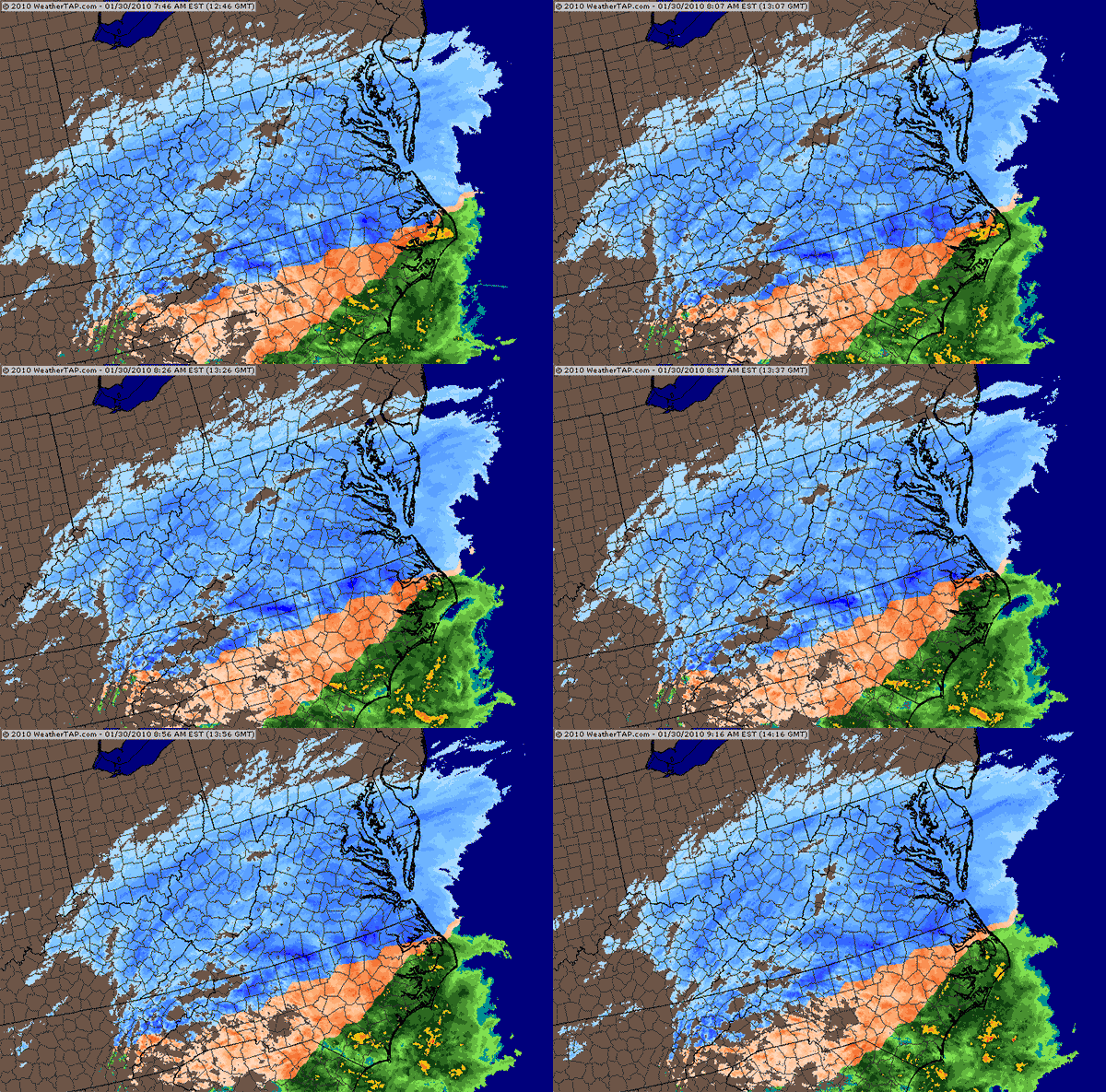
January 30th, 2010---: We really haven't seen much in the way of winter weather here in NYC since our big snow storm back in December 19th. We did receive about an inch yesterday as the arctic front moved through, but that's been about it. Another major system is moving across the country as I type, but once again, we're not seeing anymore than just clouds out of this storm. Further south in Virginia snow totals are piling up fast! Parts of the Norfolk area are expecting up to a foot of snow. The big news story here are the frigid temperatures! Yesterday morning we dropped to about 19 degrees here in Queens, NY...and this morning was even worse! 14 degrees was the low here in NYC! There's a possible storm on the horizon for the next Friday time frame, but this is still almost a week out so I won't put any stock into that scenario at least for the time being. Below is a animated regional radar shot courtesy of WeatherTap showing the snows moving through the Mid Atlantic states right now.
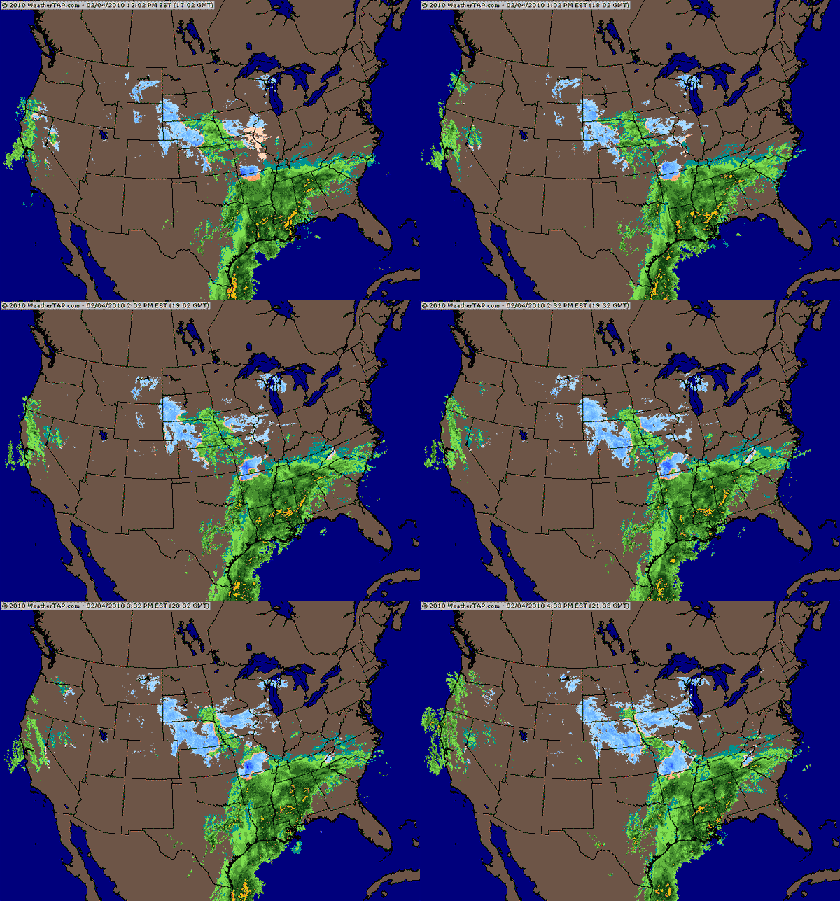
February 4th, 2010---: Here we go again! But will this storm end up being just like the last storm? A massive snow storm is taking shape in the south as I type, but current forecasts keep the worst of it to our south over southern New Jersey, and the Delmarva. Blizzard warnings are in affect for those areas, talk about close!! That's just south of us here in NYC. For us, we're under a winter storm watch currently with forecasts calling for anywhere between 4 and 8 inches of snow. I'm still skeptical that we'll see anything at all. There will be a sharp cut off line to the snow shield, and points just to the north of that cut off will receive hardly a flake. As usual, everything depends on the track of the low. The snow is forecast to begin tomorrow night here in the city, and will end sometime on Saturday....if it even starts at all! That's how much uncertainty there is with this system. My gut is telling me though that this will not be the big one of the winter season for us. Let's see if I'm wrong on that one. Below is a radar animation of this massive storm taking shape in the south (image courtesy of WeatherTap)
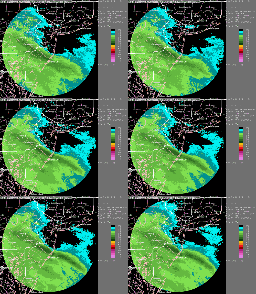
February 5th, 2010---: The NYC area is literally on the edge of a massive, make that crippling snow storm in the works right now. My area will most likely not see the brunt of this storm, but the slightest shift northward in the forecast track, and we'll get into some big snows. The current forecast calls for 3-6 inches here in the city, but points just 30 miles to my south over central Jersey are expecting up to 2 feet of snow! We'll know by tomorrow morning just how bad it's going to get here and until then, we'll have to take things literally hour by hour. Below is a local radar animation out of Philly showing the snow shield struggling to work it's way northward. How much further north will it get remains to be seen.
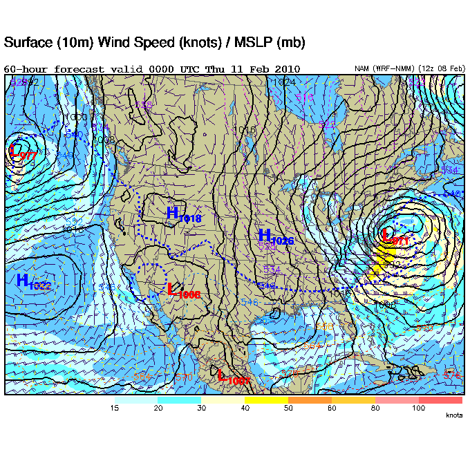
February 8th, 2010---: Well, it may be our turn this time around after all. After some model uncertainty, things are coming in line for what could be a major winter weather event here in the NYC area tomorrow night, and into Wednesday. The official forecast calls for up to a foot of snow in my area, with possible blizzard conditions through the day on Wednesday! The latest model guidance shows a low pressure system bombing out southeast of Long Island during the day on Wednesday and bringing with it heavy snows and strong winds. If this materializes you can bet I'll be out there documenting it! More updates tomorrow when things are a little more in focus. Below is the 12z Eta surface map showing what the scenario might look like come 7pm Wednesday evening. Now that's a classic nor'easter!
February 9th, 2010---: A major winter storm is forming off the Virginia coast and this time, it looks like we'll get slammed along with Philly and DC. The snows are forecast to start up overnight tonight and go all throughout tomorrow and tomorrow evening. We could even see blizzard conditions here during the afternoon. I'll be out in the thick of it and will give a full report either tomorrow night, or Thursday at the latest!
February 11th, 2010---: We're still digging out here in NYC after a major snowfall yesterday. My area in Queens, NY received about 11 inches in total, and the official total for Manhattan (Central Park) was 10 inches. I shot a ton of video yesterday and made several stops around midtown, Chelsea, and downtown. I'll be posting some of it to my YouTube channel later this evening, as well as in the "latest video uploads" section of my website. Below is a radar screen shot courtesy of WeatherTap HD showing the snow bands slamming my area yesterday evening.

February 18th, 2010---: Another round of snow hit the NYC area two days ago with a surprise 6 inches of snow in my area! Once again, it was a heavy wet snow that mostly just stuck to the grassy areas. Still though, it fell on top of what we already had and basically we have one huge mess now. Another surge of cold air may be on the way as well. The GFS model is forecasting what could be another arctic blast in about 10 days. Yes, this is still way out in fantasy land right now, so hopefully it doesn't materialize, lol. I'm just about ready for Spring!
February 23rd, 2010---: There's some rumblings about a possible winter storm here on Thursday. But as of right now, my thinking, and the models thinking is that it will be a mostly rain event for us here in the NYC metro area. Points north and west could get clobbered though. Will look at tonights model runs and will post another update tomorrow!
February 25th, 2010---: Well here's a strange storm for you. As I type another major coastal storm is hitting the NYC area with up to a foot of snow forecast in some locations. Here's the strange thing, the coastal low will be pulled back westward by another low to our west and essentially will make a loop d' loop right over the tri-state area! This means that we're in it for the LONG haul on this one. Another thing of note is that the rain/snow line is pretty much right on top of us as well. Areas to our west could see two feet of snow, and just to our east it's all rain. Queens, NY where I live is literally right on that boundary and we've been back and forth between rain and snow all day so far. As I type however, we have switched back to all snow, and it may stay this way for the duration of this event. We'll be dealing with this through tonight, and into the better part of tomorrow as well, as I said, this will be a very long duration event. Well, better get out there and start shoveling! lol...we've already got about 3 inches on the ground with MUCH more to come it seems. Below is an animated radar image courtesy of WeatherTap showing where that rain/snow line is currently.

February 26th, 2010---: We're still digging out after getting slammed by this latest winter storm. If anything, this storm brought with it more snow that any other single storm this season so far. Central Park clocked in with 20.9 inches of snow! And here in Queens where I live we received right about 15 inches give or take. A major storm for sure, and one that I'll be digging out of for a few days. Right around sunrise is when we were getting the really heavy stuff, with snow fall rates approaching and surpassing 2 inches an hour! I headed out the door and shot video from around the area. I didn't have to go far as there was chaos everywhere! City buses were slipping and sliding all over the place, and there were numerous accidents on the highways and side streets. I encountered several of them myself, but thankfully was not involved in any!
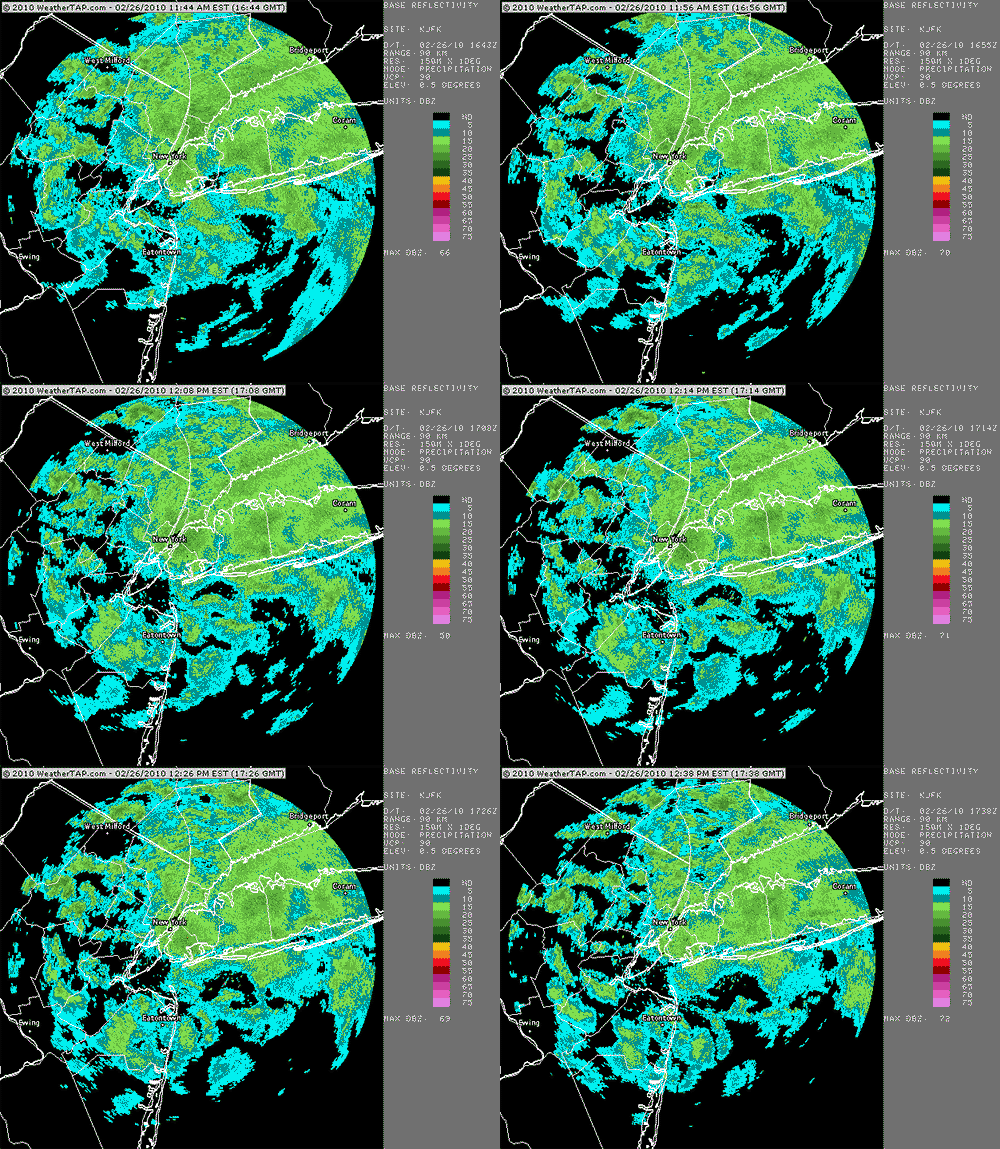
I've posted some video to my YouTube channel of this latest event, and I've also posted it in my "Latest Video Uploads" section. Check it out, and if you also have a YouTube channel, shoot me an email and subscribe to stay updated on all my latest chase adventures! Below are a few radar animations courtesy of WeatherTap showing the storm really wrapping up yesterday evening, and the second image shows the low pressure responsible for all the snow sitting almost on top of NYC earlier this afternoon.

March 4th, 2010---: Finally after what seems like an endless winter, we're poised to get some warmer weather here in NYC! All right, it's not exactly going to be a heat wave or anything, but temperatures in the lower 50s sounds pretty good to me right about now! It's a sign that spring is not far off. Just two months from now we could be on the road again chasing storms! And speaking of storm chasing, preparations have already begun and I'll be re awakening my Storm Chase blog once again very soon.
March 10th, 2010---: What a great past few days we've had here in NYC!! 3 days in a row of temperatures in the low 60s, a sure sign that winter is losing it's grip. But, we're not out of the woods quite yet. The later half of this week, and into the weekend will feature cooler temps, and rainy conditions. Still though, even though it will be raining the temperatures will remain in the 50s. So all in all that's not too bad. And, in other news....I have resurrected my storm chase blog as we are starting to get close to this years storm chase in Tornado Alley!!
March 13th, 2010---: We're getting slammed right now with one heck of a nor'easter. But unlike the last few, this one does not have any snow with it, this time around it's ALL rain and lot's of it! We've been receiving bouts of torrential rains all day long and as we head into this evening, the winds will really start to increase. There is a high wind warning in effect for the NYC area, with gusts up to 60MPH expected! That will for sure bring down some trees and power lines. Sporadic power outages are expected as well. My rain gage here in Rego Park, Queens has already registered well over an inch of rain since this all began yesterday evening. Below is an animated regional radar image courtesy of WeatherTap showing the heavy rains heading towards the NYC area.

March 17th, 2010---: Talk about a deluge! The NYC area received over 4 inches of rain from this latest Nor'easter! While there were no trees and power lines down right in my immediate area, area-wide there were literally thousands of trees down! The reports and images on the local news were incredible. Flooding, trees down, power lines down, and regrettably...a few fatalities have been reported. Today however is about as opposite as it can be. Temperatures in the 60s under sunny skies. Spring is here! But, there's still plenty of time for more cold weather so I won't pack away the winter jacket just yet.
March 29th, 2010---: We've barely dried out from the last soaking of rain we received a week ago, when yet another strong system is slamming the northeast right now as I type! Major flooding is expected once again in the NY/NJ area as the already swollen creeks and rivers cannot handle any more rains. I reset my rain gage yesterday evening right before the rains started, and since then we've already gotten about 2 inches of rain! And, there's much more on the way. There's already talk that this March will go down as one of the top 5 rainiest months on record for NYC. I can believe it with all the rains we've gotten this month. Below is a regional radar animation courtesy of WeatherTap showing the what seems like endless stream of rain moving up the coast, into the northeast. The silver lining in all of this is that we're expecting a return to spring later this week, and could even see temps in the 70s by Friday, into the weekend!
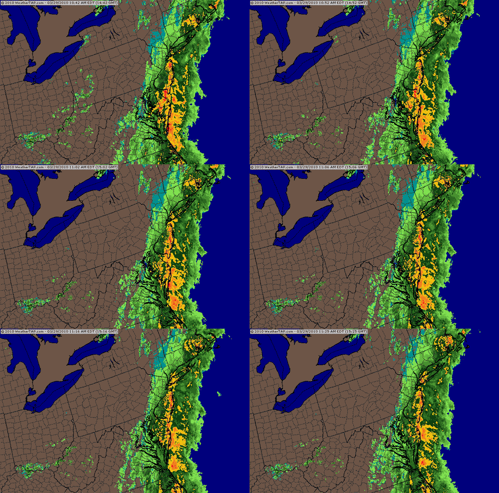
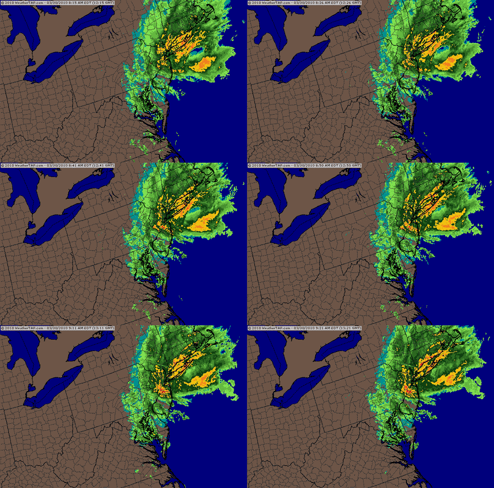
March 30th, 2010---: Day Two- It's STILL raining here as this slow moving nor'easter makes it's way up the coast. Starting around 3am last night, the rains went from moderate, to a heavy wind driven rain and it's still coming down as I type! I reset my rain gage shortly before the rains began two days ago, and since then, we have received 4.52 inches. The worst will be over with soon and this will begin our transition to much more spring like conditions here in the NYC area. Temperatures by late week will be in the lower 70s, and the Easter weekend is looking just as good! But first we have to get through this latest storm. Below is a regional radar animation (courtesy of WeatherTap showing the heavy rain bands moving onshore just a little while ago.
April 6th, 2010---: Finally!! After a very long winter here in the northeast, spring has finally sprung!! Actually, it's more like summer today than spring. Temperatures this afternoon will top out near 80 degrees now that the warm front has moved on through, and tomorrow we could see record high temps in the NYC area!! The forecast calls for mid 80s here tomorrow! No complaints from me, I like the warm weather! But, reality will come crashing down on us again this weekend when temps will fall back to more seasonable levels. Highs in the 50s are expected.
April 8th, 2010---: Yesterday wasn't just warm here in the NYC metro area, it was down right hot!! Not only did we reach 90 degrees, it was the earliest we have ever reached 90 degrees here in NYC! Temperatures topped out at 92 in Central Park. WOW! Today is less hot, but still way above normal. A cold front will approach from the west late this evening and there is the slight chance it could spark off some storms in my area. However, with the influence of the marine layer...I won't be holding my breath. The best stuff will be north and west of NYC I think. Still though, I'll keep a watchful eye. Below is the Public Information Statement from the NWS regarding yesterday record breaking temperatures.
PUBLIC INFORMATION STATEMENT...CORRECTED
NATIONAL WEATHER SERVICE NEW YORK NY
815 AM EDT THU APR 8 2010
...MANY DAILY RECORD HIGHS SET YESTERDAY...
RECORD HIGH TEMPERATURES FOR APRIL 7TH WERE SET AT THE FOLLOWING LOCATIONS...
LOCATION.....HIGH...PREV...YEAR
HIGH
CENTRAL PARK...92....89....1929
LAGUARDIA......91....86....1991
KENNEDY........87....81....1991
ISLIP..........85....81....1991
NEWARK.........92....85....1991
BRIDGEPORT.....81....73....1997 AND PREVIOUS YEARS
ALSO...THE 92 DEGREE READING IS THE EARLIEST 90-PLUS DAY ON RECORD AT CENTRAL PARK.
April 16th, 2010---: Well it was nice while it lasted! Temperatures here in the NYC area have been well above normal for most of the month. Temperatures in the upper 60s and 70s were the norm, but alas...it couldn't last forever. Now it's time to fall back to what we normally see this time of year which are temperatures right around 60 degrees. The trees are exploding with color here in the NYC area and if anything, they are a few weeks ahead of schedule. During a normal spring our trees start to bloom around the third week in April. This year the trees and plants started to pop during the last week in March! As I type this they appear as they would in late April or early May. No complaints from me as I love this time of year!! By the middle of next week the forecast calls for temperatures to rebound back to the mid and upper 60s once again!
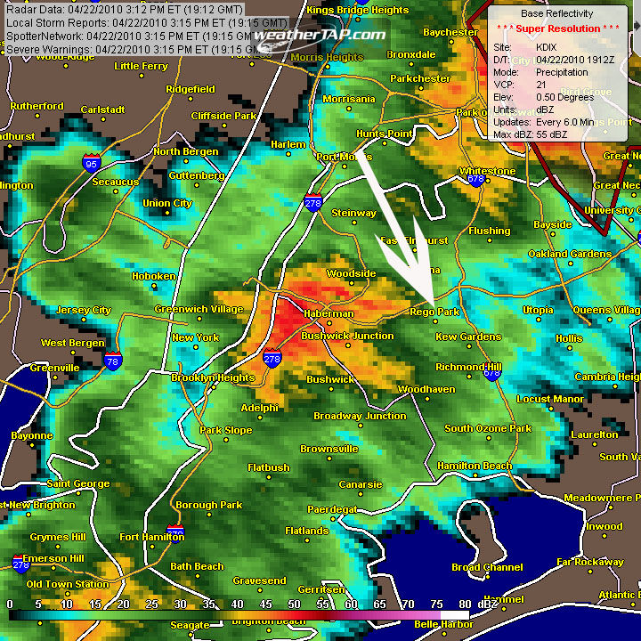
April 22nd, 2010---: The first thunderstorms of the spring storm season hit NYC this afternoon with heavy rains, and cloud to ground lightning! This was quite a surprise as we weren't really expecting any border line severe weather here today. While there was the possibility of some showers and maybe a rumble of thunder, what we ended up getting was a bit better than that! Right about 3pm the skies darkened and before long, the lightning was flashing and the skies opened up. Below is a radar capture courtesy of WeatherTapHD showing the storms as they moved into my area. The arrow is pointing towards Rego Park, Queens which is where I live.
April 29th, 2010---: After a very chilly few days this week, warmer...make that MUCH warmer weather is headed our way! Temperatures by tomorrow will be in the mid and upper 70s, and by Saturday our forecast highs are expected to be in the low to mid 80s! That's more like July than early May. No complaints from me though, hopefully we'll even see a few thunderstorms roll through with the passage of a cold front early next week. Spring has definitely arrived and I'm welcoming it with open arms!
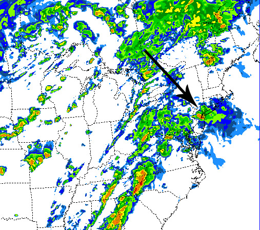
May 2nd, 2010---: Severe weather is possible in and around the NYC area later this afternoon and evening as a hot and humid air mass remains in place over the region. The past three months have been months of "extremes". We had our snowiest February on record, followed by our wettest March on record, followed by our warmest April on record! Unreal! And May is definitely off to an above normal start. Temperatures yesterday reached the upper 80s, and today we'll get to the mid 80s but with much higher humidity than yesterday. Dewpoints are already in the mid 60s and it's only 11am. With the heat and humidity will come a threat for storms and the SPC has us on the eastern edge of a slight risk for today. Our first slight risk of the spring season! The WRF precip model is forecasting storms just west of us by 8pm this evening. I am quite fond of this model as I have seen it verify more often than not. I have posted the WRF's simulated radar map for 8pm this evening, note the storms just west of NYC! We'll see if this verifies. Stay tuned!
June 10th, 2010---: Another month has gone by and summer is just about upon us! I was away chasing storms for much of May so I hadn't gotten the chance to update this page much. The past month here in NYC featured more above normal temperatures where we regularly had temps more in the late July range, than May. This trend continued up until just a few days ago when we finally had a cool down of sorts as a sharp cold front moved on through the tri-state area. I was anticipating some severe storms to accompany the front, but nothing materialized. There is the slight chance of a storm today, and a better chance on Sunday/Monday as the warm and humid conditions return to my area.
June 16th, 2010---: I've just signed up for a live streaming account with the folks at ChaserTV.com and will begin live streaming of any and all NYC thunderstorms this summer! I'm very excited about trying this out. Now all we need is for nature to cooperate and give us a storm. I also plan to live stream any hurricane intercepts I go on this year so be sure to check back often for the latest updates. On days when severe weather is possible, you will see the "live streaming" button on the navigation panel to the left flashing.
June 26th, 2010---: The heat continues here in the NYC and it appears that we will close out June on the hot side. This entire month has featured above normal temperatures and I'm not really complaining. I kind of like it on the hot side so it's all good to me. I'm sure many folks would disagree with me however, lol. In other news, the northeast is still reeling from a major severe weather outbreak that occured two days back on the 24th. I did my best to intercept a severe storm that blasted through northern Queens, and produced golf ball hail near the Throgs Neck Bridge...but the typical NYC mid afternoon traffic prevented me from getting into position in time. Bridgeport, CT sustained tons of damage, and there even was a confirmed EF1 tornado there! Glen Cove, LI and well as other parts of Nassau and Suffolk Counties sustained damage as well. I'm hoping to get another crack at chasing this coming Monday. Right now, things look to be coming together for what could be round two. But, chasing in the metro/tri-state area is extremely difficult, and that's putting it mildly. Traffic and road networks are always an issue, so I may have to commit to a target early, and then keep my fingers crossed that it verifies. More updates to come so be sure to check back.
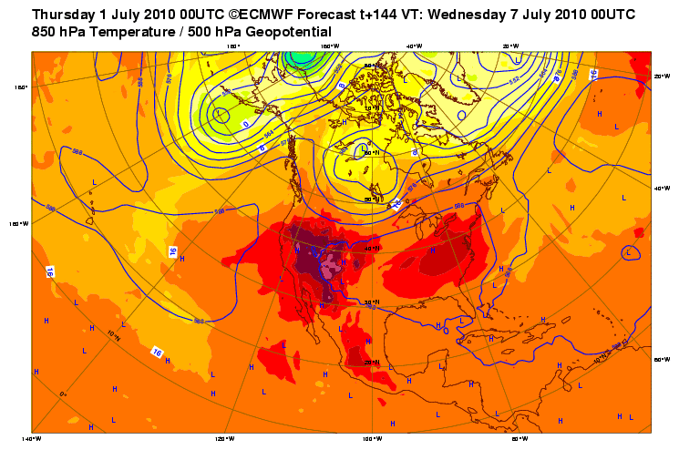
July 1st, 2010---: For several runs now, many of the reliable forecast models have been showing what could be a major heat wave taking shape for the NYC area starting on the 4th of July! The ECMWF or "European Model" has been consistent in showing a building ridge of high pressure along the east coast that will pump in hot and humid weather into the northeast. The exact severity of the heat wave is still uncertain at this time, but this has the potential to be a doozy for sure! The other thing with this particular set up is that the forecast calls for dry conditions throughout the duration of the heat wave, making an already tough situation even more dangerous since there may be no relief from the building heat. This however could change if any mesoscale disturbances under cut the ridge. If so, then we could see a few bouts of storms. Fine by me! It's been forever since I've seen a good thunderstorm around here, and a break here and there from the heat would be very welcome. More updates to come as the forecast comes more into focus. Below is the current run of the ECMWF showing the building ridge and coinciding heat for next Tuesday in the east.
July 6th, 2010---: The heat is ON big time here in NYC, and today is the worst of it! Central Park hit a record high today at 2:20pm of 102 degrees! This is the first time since 2001 that we broke the century mark. As I type it's still 101 degrees here at my place in Rego Park, Queens. The dew points were higher today as well giving us a heat index of between 102-105 degrees. The heat wave began for us on Sunday, July 4th but the past two days weren't as oppressive as they could have been since the dew points were only in the mid 50s, that changed today and now we're getting dew points into the mid 60s. Tomorrow will feature more of the same conditions, however the forecast does call for the actual air temperature to be a little lower (only into the lower 90s, lol). But, the humidity will be even higher tomorrow so we'll be facing heat indexes once again into the low 100s! A break in this pattern will come towards the weekend as a cold front works it's way through the area. Hopefully we'll finally get to see some storms around here!
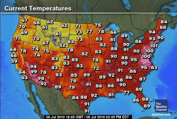
July 9th, 2010---: Our latest heat wave is coming to end end, but this relief from the high heat might be short lived. There are some indication by the models that things could begin to heat up again next week. The forecast calls for above normal temperatures through next week. A cold front is also forecast to move through the NYC area tomorrow mid day and will bring with it the possibility of strong storms and torrential downpours. With this tropical air mass in place, it's certainly possible. The current dew point is 73 degrees! Definitely sultry outside. Below is the official NYC Weather Service bulletin regarding our July heat wave.
PUBLIC INFORMATION STATEMENT
NATIONAL WEATHER SERVICE NEW YORK NY
546 PM EDT WED JUL 7 2010
...JULY 2010 HEAT WAVE...
A HOT AIRMASS WHICH DEVELOPED OVER THE CENTRAL PORTION OF THE UNITED STATES TRANSITIONED EASTWARD AND SETTLED OVER THE REGION DURING THE SECOND HALF OF THE JULY 4TH WEEKEND. AS THE WEATHER PATTERN STALLED...THE AIRMASS WAS ABLE TO WARM FURTHER DUE TO A LACK OF MOISTURE OVER THE REGION.
SEVERAL RECORDS HAVE BEEN BROKEN. THE FOLLOWING IS THE MOST RECENT DATA WITH REGARD TO THE HEAT WAVE.
...NEW YORK...
...LOCATION... ...7/4... ...7/5... ...7/6... ...7/7...
CENTRAL PARK 96 99 103 100
FARMINGDALE 98 99 102 98
WESTHAMPTON BEACH 97 97 100 94
WHITE PLAINS 95 96 102 97
SHIRLEY 98 98 103 95
ISLIP 97 95 101 96
JFK AIRPORT 101 97 101 100
LAGUARDIA 98 99 103 101
MONTGOMERY 94 96 100 98
MONTAUK 88 91 96 87
...NEW JERSEY...
...LOCATION... ...7/4... ...7/5... ...7/6... ...7/7...
NEWARK 101 102 103 101
TETERBORO 97 99 103 101
CALDWELL 96 98 102 100
...CONNECTICUT...
...LOCATION... ...7/4... ...7/5... ...7/6... ...7/7...
BRIDGEPORT 97 93 98 95
DANBURY 97 95 100 98
GROTON 90 92 101 86
NEW HAVEN 94 95 100 98
MERIDEN 96 97 102 99
...RECORDS BROKEN AT NWS CLIMATE SITES...
...LOCATION... ...DATE(S)...
CENTRAL PARK 7/6 AND 7/7
LAGUARDIA 7/6 AND 7/7
JFK AIRPORT 7/4, 7/6 AND 7/7
NEWARK 7/6
BRIDGEPORT 7/6 AND 7/7
ISLIP 7/4, 7/6 AND 7/7
...NOTABLE STREAK...
NEWARK REACHED 100 DEGREES OR GREATER FOR 4 CONSECUTIVE DAYS.
THIS TIES THE RECORD ESTABLISHED IN BOTH 1953 AND 1993.
July 21st, 2010---: Starting on July 4th NYC entered into a heat wave and it for the most part hasn't let up! The majority of the days here in the city have featured temperatures at or above 90 degrees almost every single day since the 4th! Today is no exception. And, on top of the heat we've also had high levels of humidity thrown in for good measure. Not that I am really complaining though. Most folks would disagree with me but I really don't mind the heat and humidity. But, I don't like the high electric bills that come along with the heat! Still, through all this heat and humidity our thunderstorm season has been for the most part, non-exsistant! We haven't had one good storm here all spring/summer. Today, we've under a severe thunderstorm watch and overall it's quite an active day here in the northeast. Supercell thunderstorms are roaming NY State as I type but will we see anything down here in the city, most likely not. This has not been our year for storms, at least so far. I'll be keeping an eye to the sky regardless and will live stream any storms that head this way. Getting back to the heat for a moment, the hot and humid conditions will prevail into this weekend and at least for now, it appears that a break in the heat will take place next week.
August 15th, 2010---: Been a few weeks since I've updated but that's mostly because things have been quiet on the home front. We did however experience our 2nd hottest July on record. Now when I say 2nd hottest on record I mean the 2nd hottest by just a fraction of a degree. I think it was something like a .1 or .2 degree difference between the hottest July we've ever had, and where we finally ended up with our 2nd hottest July ever. Basically, I see it as tying the record. It was HOT let's just put it that way. However, we didn't see much in the way of rains or storms and this trend is continuing into August. We have experienced a cool down lately but tomorrow we've looking at another hot one and the SPC does have us in a slight risk of severe weather. We'll see! Either way, I'm hoping the warm weather continues for at least another few weeks. Before we know it, Fall will be here and I'm not necessarily a fan of the cold. The longer summer lasts, the better I say!
September 21st, 2010---: The clean up continues in the wake of last Thursdays 125mph macroburst and tornadoes! What a week it has been. My neighborhood was forever changed by this storm, and trees that I used to climb when I was a child, are no longer standing. Insane. In case you haven't seen the video yet, I have posted a six minute video of the storm hitting, and the chaotic scenes immediately in the wake of the storm. The video can be found on my YouTube channel (link is on my home page), or you can click on the "Latest Video Uploads" link to the left to view. In other news, it looks like summer will have one final gasp late this week when temperatures are forecast to soar into the 80s once again! No complaints from me! My 38th birthday is also just around the corner. Wow, where did the time go. Say goodbye to summer too, today is the final day before fall begins.
September 26th, 2010---: Things are almost back to normal around here after being hit by one of the worst storms in literally a century. The tree shredders showed up two days back and cleaned up what was left of the tree debris on the side of the roads in my neighborhood. So, now that things are getting back to normal, my attention is turning to the fall season, my upcoming trip to London, and the fall nor'easters that are common around here during this time of year! If you haven't checked it out yet, I've posted some new videos to my YouTube channel, and here on the site as well in the "latest video uploads" section. Check them out!
October 3rd, 2010---: Now that the fall season is settling on in, this is the blog that I will be updating more often than my storm chase blog. That is, until next spring when we start gearing up once again for Storm Chase 2011! The weather here in NYC this weekend is definitely fall like, and the trees are already beginning to show signs of fall colors. We're still several weeks away from the peak of the fall foliage, but the signs are there that the cold weather is on the way. In other news, the annual PDN Photo Expo at the Javitz Center in Manhattan is coming up, and once again Dave Lewison and I will be in attendance. I'll also be heading to London for a weeks vacation this coming Thursday, October 7th! Never been overseas so I'm really looking forward to it!
October 7th, 2010---: I'm finally doing something I've never done before. I'll be heading overseas for the first time ever! My girlfriend Cecelia, along with my father and I will be taking a week's vacation in London, England starting today. The weather looks to be great for our trip as well with sunny to partly sunny skies forecast for the entire time we're there! Photos will be posted upon my return, but in the meantime...if you haven't looked recently, check out my "New Photos" section located in the photo gallery. I've posted a ton of photos taken in the after math of the 125mph downburst/tornadoes that hit my neighborhood of Queens, NY back on September 16th!
October 16th, 2010---: Back from London and what a trip it was! If you're interested in checking out some photos of my latest trip I have several photo albums posted on my Facebook page! The link to my FB page can be found right on my home page. At some point I'll probably get around to posting them here on my website as well. In weather news, upon our return we were greeted with some very fall like weather! Temperatures here in NYC have been in the very chilly low to mid 50s range and the winds have been howling the past 24 hours. This as a result of our most recent nor'easter. Speaking of nor'easters, it won't be long now until we get into our snow season, I wonder what this winter will bring. Hopefully a few good snow events! All though I'm sure many people would disagree with me on that one! Next month, Cecelia and I along with Dave Lewison and Stephanie LaRose will be heading up to Canada for a storm chaser get together! This will no doubt be tons of fun, but first...our annual trip to the PDN Photo Expo at the Javitz Center is just two weeks away!
October 25th, 2010---: A little Indian Summer is taking place right now in the NYC area! Temperatures today reached the low 70s under partly sunny skies, and more of the same is on tap for tomorrow. Cecelia and I will be taking a trip into Manhattan tomorrow afternoon to photograph some of the fall foliage in and around Central Park. Then, on Wednesday things could get interesting around here with a threat of severe weather in the forecast. There's already a moderate risk for severe storms forecast by the SPC for tomorrow in the Ohio Valley, so hopefully some of that will be saved for us here in the city the following day. I could use one more good round of storms before the long fall and winter settle on in.
November 4th, 2010---: The first nor'easter of the fall season arrived today but unlike future nor'easters, this storm brought with it just rains and winds. All in all we're getting a good deluge here in NYC with more rain on the way this evening before all is said and done with. After the storm winds down, we're in for some pretty chilly conditions this upcoming weekend. Fall has definitely arrived! In other news, I'll be heading up to Canada later this month for the first time! We'll be having a get together with our fellow Canadian storm chasers at our good friend Mark Robinson's cottage. Can't wait for that!
November 14th, 2010---: We're coming to an end of what was an amazing stretch of mild and sunny weather here in the NYC area! Which just happened to coincide with my friend Jeff's visit from Los Angeles. The past few days have been above normal temperature wise with temps in the mid 60s under sunny skies. Today is a little cooler than yesterday, but still above normal for this time of year. The party will be coming to an end however as cooler temps and rainy conditions will be the norm for the early/mid week period. In other news, Cecelia and I will be heading to Canada next weekend to visit with some of our Canadian storm chaser friends! Should be a great trip!
November 18th, 2010---: Strong winds and mild temperatures were the main headlines yesterday here in the NYC area. Gusts to around 40-50mph were common yesterday, and several power outages were reported throughout the city. Today is much calmer as far as the winds are concerned, but it's a bit on the chilly side. It's mid Fall however so we're not really experiencing anything out of the norm. The next few days will feature seasonal temperatures and very little, if any rain. In other news, I'll be taking a trip up to Canada this weekend to visit with some of my fellow Canadian storm chasers! Our good friend Mark Robinson is hosting a chaser get together at his families cottage north of Toronto. It's sure to be a blast, but we'll have to bundle up as it's going to be much colder there, than here in NYC!
November 29th, 2010---: Now that the Thanksgiving holiday is over with, and our trip to Canada is complete, it's time to get moving on something that I've been meaning to do for quite some time now. Re-launch and re-vamp PSPhoto! I'm just not happy with the "frames" aspect of this site anymore, it's outdated, and it makes it very difficult for the search engines to catalog the website correctly. So, I'm moving away from frames in favor of a conventional navigation bar that will be displayed on every page of this site. Many more suddle changes will be made as well, but overall I can say this...PSPhoto will be much more easily navigated after I'm done with the re-vamping project. I expect to re-launch by later this week!
November 30th, 2010---: The weather will rapidly go down hill this evening and into tomorrow morning as a major coastal storm takes shape bring heavy rains and high winds to the northeast, including the NYC area. This same storm system is responsible for multiple tornado reports both yesterday and today. One tornado came very close to the Yazoo City, MS area for the second time this year! Damage was reported in town but thankfully I have not heard of any serious injuries so far. While this upcoming storm event will not be of the frozen variety, it won't be long now until we start seeing the first flakes fly here in the city.
December 6th, 2010---: The first snow flakes of the season started flying today here in the NYC area. A retrograding low over Quebec brought cold northerly winds, and snow showers to the tri-state area today. No accumulations in the city, but areas north and west did see some accumulations and areas even further north received some hefty lake effect snow totals! My good friend Mark Robinson (www.stormhunter.ca) was out in the thick of it in southern Ontario this afternoon and evening. Below normal temperatures will be the norm throughout this week and there are some signs that things could get even colder next week! There is also a storm system being shown by several of the forecast models for this area come late weekend and early next week. Right now it appears that the NYC area will be on the warm side of this storm, but regardless...it won't be long now until the real snows begin to fly! On another note, I hope everyone likes the new look of my website. It's much easier to navigate now I think.
December 9th, 2010---: For several days now an arctic air mass has had it's grips on many US cities, and New York City is just one of those cities. Morning lows have been in the middle 20s with highs in the low 30s, well below the norm for this time of year! There's no way to know for sure what the rest of the winter will bring, but it does appear at least right now that the cold grip will only briefly wane, before another shot of arctic air settles on in next week. Now, as far as this short break from the cold, unfortunately it will come at a price. And that price is some rainy weather come Sunday, into early Monday morning. However, at least as far as I'm concerned, I'll take temperatures near 50 with some rain, than the 30 degrees it is outside right now, lol. Below is the 12z (7am) GFS Model forecast showing the low pressure system moving to our west this weekend. According to this forecast model, this is what the set up should look like come 0z (7pm) Sunday evening. Note the center of the low pressure system is to the north and northwest of NYC by that time, that would put us on the warm side of this system so I'm fully expecting an all rain event. However, if the cold air can surge back in quickly as the low departs the area, and there is some left over moisture present, then we could see a burst of snow here in the NYC area before all is said and done. The next system on the horizon appears to be around the 19th or the 20th. More updates to follow. Speaking of following, you can now follow me on Twitter (www.twitter.com/scottmcpartland) or if you don't have a Twitter account, you can subscribe to my RSS Feed at (www.twitter.com/statuses/user_timeline/224362254.rss) By following me and/or subscribing to me you will be automatically updated everytime I update this blog, as well as my storm chase blog!
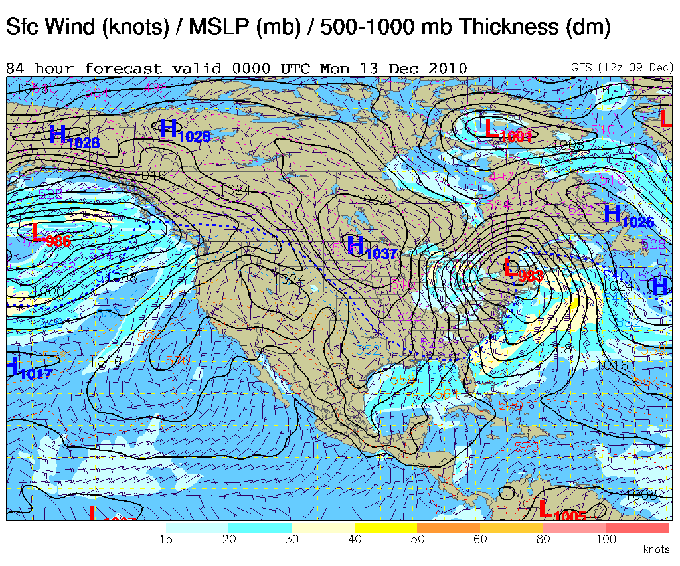
December 11th, 2010---: A large and complex storm system will affect the majority of the east coast late this weekend, and into early next week. Right now there are blizzard warnings in effect for pretty much all of Iowa, and parts of Minnesota. This is one HUGE storm system without a doubt! As far as our weather in NYC in concerned, we'll be on the warm side of things here and are expecting an all rain event. However, there could be some mixing of sleet, freezing rain and some snow north and west of NYC at the onset of the storm late tonight and early Sunday morning. By Sunday mid day things here in the tri-state area will be going down hill, and we can expect moderate to heavy rains at times (totaling 1 to 2 inches) and there is also the possibility of strong winds mixing down to the surface during the afternoon. All in all, a very crappy Sunday is in store, so get out there today if you have weekend chores to do! Below is the 0z Saturday (7pm Friday) GFS model forecast showing how things should look come 7pm Sunday evening. If all this verifies they'll be some serious snows taking place in western NY state, eastern Ohio and Michigan with rain all along the east coast. One good thing about this storm system at least for us here in NYC is that we'll get a brief break from the below normal temperatures we've been experiencing lately. But this won't last long at all. After this storm departs the area, we'll get back into the bitter cold temperatures once again for the majority of the upcoming work week.
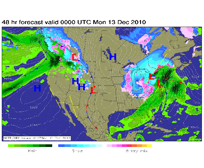
December 12th, 2010---: Intense rains bands bringing with them strong winds are affecting the NYC area today. Getting nailed with one after the other here. Updates throughout the day via my twitter page (www.twitter.com/scottmcpartland) Below is a radar screen shot taken a short time ago showing the sheer massiveness of this storm system! As you can see, we are on the warm side of things here in NYC with heavy snows and blizzard conditions off to our west.

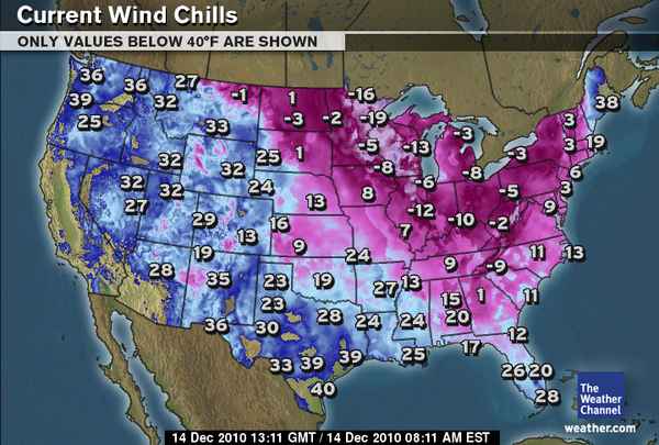
December 14th, 2010---: Holy moly talk about an early season deep freeze! Temps in the mid 30s, as far south as Miami??!! Yep, that's what the US is facing this morning..and the worst is yet to come. I awoke here in NYC this morning to temperatures in the mid 20s and a dusting of snow for good measure. Much of the US is locked into well below normal temperatures, and tonight will be even colder. Our lows here in NYC will bottom out in the mid teens, and highs tomorrow will only reach the mid 20s once again. However, with winds gusts in the 30 to 40mph range tomorrow, it will feel even colder than today! Check out the current temperature and wind chill maps as of 8am this morning, yikes! Switching gears momentarily, a few of the reliable forecast models are showing a possible coastal storm for next Sunday/Monday. Right now it's looking like the storm will stay far enough off shore to spare the northeast from any significant impacts, but I'll be keeping an eye on things regardless. Stay warm out there!

December 16th, 2010---: Much uncertainty still remains in regards to the weekend coastal storm that could affect the northeast late this weekend. The models have been doing the old flip flop the past few days and late last night it did appear that the worst of this storm would stay well off shore. Now, not so sure. The latest run of the models are once again showing a track closer to the coast. First it was the Euro (ECMWF) model that was latching on to an off shore scenario the past few days, then finally...the GFS model began to side with the Euro yesterday and it appeared that the Euro (ECMWF) was going to win out here and be dominate model for this particular storm. Then this morning I ponder over the 0z data, which came out around 2am local time and the Euro did a complete about face! It's now showing a closed H5 low very near the 70/40 benchmark. The 70/40 benchmark is the latitude and longitude point where if a low pressure system moves close to, or over it can bring a significant snow storm to the areas in and around NYC. The 12z GFS just came out and it is also showing (once again!) a track closer to the coast, lol. Needless to say, a very tough forecast as the slightest difference in the ultimate track of this storm will have big implications on how much, if any snow we get here in and around NYC. As challenging of a forecast this is, I do get enjoyment out of trying to figure out what will happen. Right now, I'm 50/50 on what can happen. Yeah, I know...I can't commit right now to an outcome. However, much will come into focus today I believe and we should have a much better idea later tonight, and tomorrow morning as to what this storm will do. Stay tuned!
December 17th, 2010---: The forecast models continue to struggle regarding this weekends coastal storm. As of now, the consensus appears to be for a weaker low pressure system, east or southeast of the 70/40 benchmark which translates to less snow for the NYC/tri-state area than it appeared earlier. Heavier amounts are possible east of NYC over Long Island, but this would also depend on how much, if any rain mixed in with the snow. The models overall appear to be struggling more than usual with this particular storm. The ECMWF (Euro) has been swinging wildly the past few days and it had just come to my attention that the Euro ensemble mean consists of 50 members! For those of you that have no idea what I just said there, lol...let me translate. Basically disregarding all the weather geek technical mumbo jumbo the Euro model has a LOT of information going into it and therefore, for the most part is a very reliable model. Especially when you get within a few days of an event. But the evolution of this storm is proving quite challenging and the Euro, along with the GFS and other models are having a tough time of it. Speaking of the GFS, I will say that overall the GFS hasn't been swinging as wildly as the Euro, so personally I am putting more weight on that model which has been somewhat consistent in showing a weaker low, further off shore the past few runs. It should also be noMy gut is telling me that we're looking at a light snow event here in NYC. Hopefully they'll be more run to run model consistency with today's runs, I am expecting this to happen. So the saga continues...more updates to come.
December 17th, 2010---: **UPDATE** The forecast models are coming into better agreement this afternoon, and it is looking more and more likely that the coastal storm forecast for this weekend will stay well off shore. Doesn't look like the big one this time around, but technically it isn't even winter yet! Still plenty of time for a few whoppers. The NYC/Tri-State area could still see some snow from this system, but right now it's not looking too significant. Will continue to monitor regardless.
December 18th, 2010---: So while this weekends coastal storm never panned out for those of us here in the northeast, there is now another threat potentially on the horizon for the NYC/tri-state area. For the third run in a row now the GFS model has been advertising a low pressure system moving east through the southern states through late week. This low bombs out (strengthens) as it moves off the east coast and then swings up the coast very close to the 70/40 benchmark! Now granted, this is still a week out so many things can still change with the forecast, but it is something of interest to watch unfold for sure! I won't put too much stock into this right now, but a Christmas Day nor'easter is something you don't see very often, and for now anyways....is a possibility. Below is the latest 06z run of the GFS showing this potential storm off the northeast coast on Christmas Day. Many more updates to come!
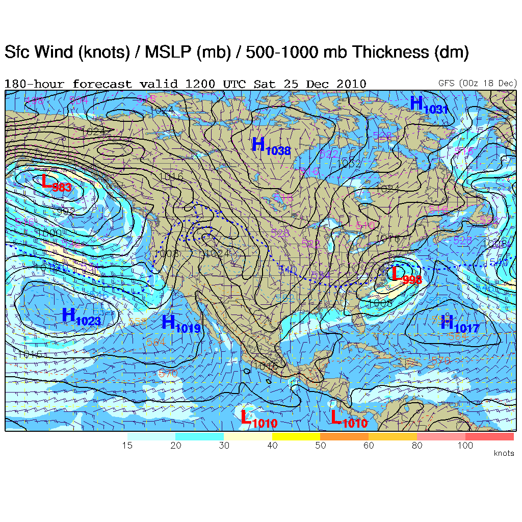
December 19th, 2010---: The GFS forecast model, one of the reliable models I use in my forecasts is still signaling the possibility of a major coastal storm on Christmas Day. This is about the 7th or 8th run in a row now, so as far as that particular model is concerned, we are getting run to run consistency. The latest 0z (7pm last night), 06z (1am this morning), and the hot off the press 12z (7am this morning) control runs are tracking this storm very close, if not over the classic 70/40 benchmark. I took a quick look at the 0z GFS/NCEP spaghetti plots and for now at least, we're getting agreement there as well. What should also be noted is that the other reliable medium range model I use, the ECMWF (Euro) is now on board with this storm as well. Will all this change over the coming hours and days? Most definitely, at least to some extent. Whether it will be for the better or worse (depending on how you look at things) remains to be seen. But one thing is for sure, a Christmas Day nor'easter is something you don't see very often and it will be an exciting week for me watching how all this unfolds! Below is the latest 12z run of the GFS showing this potential storm over the classic 70/40 benchmark on Christmas night. Once again to reiterate, this is still 6 days away so take this forecast, as with all weather forecasts almost a week out with a grain of salt. It's not written in stone yet, but needs to be monitored since many folks will be traveling, or are planning to travel on this day.

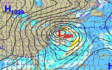
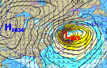
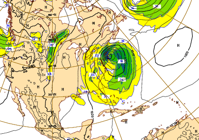
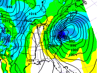
December 21st, 2010---: As I ponder over the latest model runs here this morning it's beginning to appear more and more likely that we will have a major coastal storm on our hands for late this Christmas weekend. The timing seems to have slowed a bit so right now it's looking like a late Saturday (12/25), through Sunday evening (12/26) event. But, what about the all important track of the low as it tracks up the coast. Yes, this is the million dollar question, and one that just can't be answered right now unfortunately. A lot of media outlets like to hype these types of storms up, but 5 days out so many things can still change that making specific predictions like that are just pointless. However, with that said here is what it's looking like right now. The trend in the models was for a slower timing of this system as I mentioned earlier. Meaning that Christmas eve and the early part of Christmas day could be ok. But, Christmas afternoon/evening and definitely the following day could be a whole different story. Here's the model breakdown. The latest 0z GFS is showing a powerful low tracking off the NC/VA coast Saturday afternoon 12/25. The GFS is forecasting this low to track up the coast slightly inside the 70/40 benchmark late Saturday night and throughout the day on Sunday 12/26. If this scenario were to verify it could spell some significant snows for the I-95 corridor from DC to NYC. Again, way too early to get specific with possible totals. But it certainly could be a long duration event as the low is forecast to only be in the vicinity of Cape Cod by Sunday evening. The freezing line at the surface appears to run close to the coast for this event but right now it does look like it could be a mainly snow event if this set up materializes. The freezing line at 850mb (5000ft) doesn't seem to be an issue as it's forecast to be well off shore throughout the event. Now onto the ECMWF (Euro). The Euro is showing a similar set up to the GFS, but is bringing the low a bit closer to the coast, inside the 70/40 benchmark. However, the surface and 850mb (5000ft) thermal profiles if accurate would also support a mainly snow event as well. Bottom line, we just have to keep watching how all this unfolds over the next few days. With this being Christmas weekend coming up, many folks will be hitting the roads here in the northeast, so best bet is to keep an eye on the forecast and hopefully things will come more into focus over the next 48-72 hours. Again, it's still way too early to give any specifics regarding this possible storm but I do feel fairly confident that there will be a coastal storm of some sort this weekend, how far off shore the storm tracks will determine the impacts along the coast. More updates to come for sure. Below are a few forecast model maps showing what things *could* look like come 7am Sunday morning 12/26. On the left is the 0z GFS surface forecast map, and on the right is the 0z ECMWF map for the same time frame.

December 22nd, 2010---: The potential still exists for what could be a major nor'easter late Christmas weekend, however many uncertainties remain in regards to track. Nothing out of the ordinary really when it comes to a storm that's still crossing the country as I type this. Coastal storms are some of the hardest to forecast and this one is no different. So bare with me on this forecast discussion as I am going to go in depth here as to what the last few runs of the models are showing. If you're not interested in all the weather geek mumbo jumbo, lol...no worries, you can jump right to the end for the synopsis. Let's start with the 0z runs from last night. All in all I use a blend of three models for my forecasts, one of them being the CMC/GEM which up until now I haven't mentioned. The other two are the GFS, and the ECMWF (Euro). As of the 0z runs (7pm) last night two out of the three models have a significant storm taking shape off the east coast, and tracking northeast to near Cape Cod, bringing with it the potential for some big snows to the area. The outlier in all this was the GFS model, which for the third or forth run in a row now was showing a less intense storm, tracking off the east coast and out to sea, bringing no snow at all to the northeast. The latest NWS forecast discussion issued this morning is disregarding the last few GFS runs as they are outliers for the time being. I took a glance at the 0z NCEP ensembles which the GFS operational run is based off of and the operational run is on the south side of several of those members. On to the latest 12z runs which are hot off the press! The 12z GFS control run has now shifted yet again! Big surprise there. It appears at least on this run to be shifting back over to the CMC and Euro's way of thinking. Is it a trend? No, not yet at least. The GFS has been jumping the track of this low all around so for now I'll take it with a grain of salt. However, this latest run is now showing a track further to the north, a little to the southeast of the 70/40 benchmark as opposed to the last few runs which showed a less intense low tracking off the NC/VA coast and harmlessly out to sea. This latest run now shows a low bombing out (strengthening) to an insane 963mb by Monday morning, and down to 959mb by Monday evening. The 12z CMC is still tracking a strengthening low up the coast, but this run is further to the east than the last run which would spare the area from a major snow storm, but would bring snows in to the east of NYC. 12z ECMWF (Euro) is probably the most ominous of all three models as it continues to show a major snowstorm nailing the mid Atlantic and northeast. The Euro has also been the most consistent the past few days in it's handling of the track so it will be interesting to see if the Euro wins out in the end.
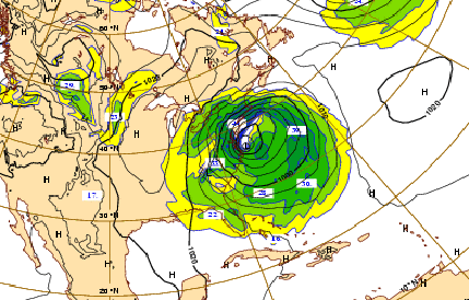
Ok, to sum it all up as of right now the general consensus of the models is for a major storm to develop off the east coast late this weekend. That part of the forecast is pretty solid. Track wise there is still the normal uncertainty this far out but it is beginning to look more likely that we could be looking at a major nor'easter affecting much of the mid atlantic and northeast come late Sunday 12/26 and into Monday 12/27. So have a plan in place in the event this materializes as many people will be traveling late this weekend and early next week. But with that said, keep in mind that a shift more off shore and you go from a ton of snow, to an inch or two, or perhaps nothing at all. The models, especially the GFS are still getting a handle on this storm so more changes in track can be expected. Below left: the latest 12z GFS operational run showing an intensifying storm off the EC Monday morning. Below right: the latest 12z operational run of the ECMWF (Euro) showing a similar set up and a major storm off the coast for the same time frame. Another full update tomorrow morning.
December 23rd, 2010---: Here we are another day closer to this potential nor'easter and the models are continuing to struggle with the track. Not all that uncommon really. All three of the medium/long range models I personally use for my forecasts, the GFS, the ECMWF, and the CMC/GEM agree on a coastal storm taking shape..there's little doubt there in my opinion, but the ECMWF (Euro) has been the most consistent out of all three over the past few days in regards to the track. This is not to say that the Euro will be the right model in this case, but when a model remains consistent, you have to take notice, especially when the other models continue to bounce all over the place. The GFS has been back and forth now with this storm, first it's inside the benchmark, then it's far off shore, then it's somewhere in between, lol...yeah, kind of hard to put any stock in that model at least for the time being. The latest 12z Operational run once again has this storm tracking further off shore than the last two runs, with minor impacts to the NYC area, heavier impacts east (Boston/Cape Cod). With that said, the GFS is a good model in my opinion, but it's struggling with this storm big time. Then we have the CMC/GEM which on it's latest 12z run is hardly showing a coastal storm forming at all, just a weak low forms and heads out to sea with minimal, if any impacts anywhere along the mid Atlantic and northeast coast. Hmmm, that's quite a 180 from the last few runs so again, I will take today's 12z run with a grain of salt for the time being. Then finally we have the latest 12z run of the ECMWF (Euro) which is continuing to show a very powerful nor'easter taking shape and passing close to the benchmark. The Euro by far has been the most consistent model here so one has to take notice, but will it be right? The jury is still out.
Here's the skinny on what needs to happen for this storm to take shape and nail the northeast/mid Atlantic. To simply, there are two pieces to this storm. The first piece is what's been hammering Southern California with insane rains and mud slides the past few days. This storm will continue to move towards the east, towards the southeast/mid Atlantic coast this weekend. There is another piece of energy (a storm) moving into the Pacific northwest. This piece of energy needs to ride the jet stream through Canada and then (if the models are correct) will dive down into the US as the eastern trough digs in, where it will meet up (or "phase") with the storm that will be making it's way towards the southeast/mid Atlantic coast. They have to meet up at the right time and then a coastal storm will take shape that could track up the coast giving us big snows. Without this northern piece of energy, the western storm would most likely just head off the mid Atlantic coast and harmlessly out to sea (much like our last system did a week ago). It's this northern piece of energy that is the key here, and the timing has to be right too. Yeah, it's a lot for the models to take in which is why they are struggling, but I do expect a clearer picture by tomorrow (Friday).
Ok, to summarize...the potential is still there in my opinion for what could be a significant snow event for the mid Atlantic and northeast states on Sunday/Monday. One model (the GFS) is currently showing minor impacts to the NYC/DC area, heavier impacts east of here over eastern Long Island, Boston and Cape Cod. The CMC has about faced on it's latest run and is hardly showing a storm forming off the coast at all. I am discounting this model run for the time being since it's drastically different from the previous runs. Then we have the ECMWF (Euro) which has been the most consistent and is continuing to show a powerful nor'easter taking shape. It's still 50/50 in my opinion so like I mentioned in my update yesterday, have a plan in place if you are traveling this holiday weekend "just in case". Hopefully, a much clearer picture will materialize tomorrow.
December 24th, 2010---: Morning update. As of now, the GFS, which was the eastern outlier appears to be the furthest west with this storm now according to the latest 0z run. The ECMWF (Euro), CMC/GEM and high resolution short range model, the ETA/NAM all have this storm pushing pretty far off shore. I'll hold out until the 12z models are in later this afternoon, but for now it's looking like a close call for the NYC area as it appears we would be on the western edge of the snows. Points further east over central and eastern Long Island could see heavier amounts, as well as central/eastern Connecticut. The offical NWS Discussion states that they are going with a blend of the ECMWF (Euro) and GFS for their current forecast, but it's certainly possible that this storm could end up pushing further east and we'd get no snow at all around NYC. As I had mentioned in my other updates regarding this storm, model consensus and model trends are something we look for, and the ECMWF (Euro) for several days was trending towards a big nor'easter. Now, not so much. Trends are important, but as we see here, that can change too as we get down to the wire. Now that we're within the 72 hour time frame for this storm I do put more weight on model trends than say, when we were still 5-7 days out. So I'm calling for a close call here in the city with just light amounts of snow. However, with three out of the four models showing this storm pushing further east, it's entirely possible that we get nothing at all. Will wait to see if this trend continues on the 12z runs this afternoon. If so, then my confidence will rise, especially if the 12z GFS comes in further east as well along with the other models. And I am expecting this to happen too. The reason? I just checked the NCEP Ensemble Spaghetti Plots which the GFS control run is based off of, and the NCEP ensemble mean, and many of it's members place this storm east of where the 0z control run is showing it, much more in line with the other models. When I see that it usually means that you'll see a shift on the next run. Will have a quick mid afternoon update once the new runs are in.
3pm Update: Well so much for the east shift I was anticipating on the 12z run! lol. The 12z GFS operational run, along with the NCEP ensembles are showing a drastic shift westward and are showing this storm slamming the east coast, and the major cities late this weekend. However, I am discounting this particular run as it is suspect according to the HPC. Apparently the 12z runs have ingested bad data and were initialized wrong. More info regarding why this run is being discounted can be found on the HYDROMETEOROLOGICAL PREDICTION CENTER website. Bottom line here as I have discussed this storm in great depth over the last few days is that it's a tough call either way. A good lesson here is to never be married to one model, or one run of any given model. Models are used as tools and are not the bible as they say. With that said, the models in this case really did do a great job in my opinion. Keep in mind, they pegged a coastal storm for Christmas weekend like a week out! Not bad at all. The thing is, when it comes to winter storms everyone wants specifics since the difference of 50 miles in track has HUGE impacts on snow totals in the major cities along the east coast. Couple that with a holiday weekend and there's a lot of pressure on forecasters to make the right call. My call on this, well if you are traveling on Sunday anywhere in the northeast keep tabs with the forecast. Right now it appears to be a close call. With the bad data on the 12z runs, we'll have to wait to tonights 0z runs to (hopefully) get a better picture. Fingers crossed the 0z runs initialize properly. Sorry I can't be more specific, still too much uncertainty...a hair puller for sure!
December 25th, 2010---: First off, Merry Christmas everyone! So what is this I awake too? A winter storm watch is now in effect for the NYC area with up to 9 inches of snow possible. Just goes to show you how tough these winter storm forecasts can be. The models have been all over the place the past few days but finally seem to be coming into focus. However, this can all still change for the better, or worse so it ain't over just yet! Yesterday it appeared the the 12z GFS was "out to lunch" when it drastically shifted westward with the track of this storm, well....it appears now at least that it may have been on to something. Bottom line, this storm has had myself, along with just about everyone else guessing the past few days. Here's what it's looking like right now, or as of the 0z runs. The GFS has shifted way west and now shows a powerful nor'easter, close enough to the coast to bring heavy accumulating snow to the NYC area, as well as the other major cities along the I-95 corridor. However, the 06z GFS shifted even a little more west. Remember, if the storm tracks too close to the coast then we get a mix of rain and snow, and possibly even all rain. The exact track is everything here and again, is why forecasting these storms accurately is so difficult. The 0z ECMWF (Euro) has once again shifted back towards the west and shows a track very close to the benchmark (similar to the GFS) bringing heavy snows to the northeast and mid Atlantic. The CMC has also shifted west from it's previous runs but it's track is a bit east of the Euro and GFS. And then you have another short range model I use, the SREF showing a track similar to the GFS and Euro. The 12z ETA/NAM is hot off the press and that is also showing a track further to the west than it's previous runs, all though not as far west as the GFS and Euro. All in all now that we're getting in very close to this event the trend in the models seems to be for a track closer to the coast than previously thought, so unless there is another drastic change, anyone planning on traveling tomorrow afternoon, evening and overnight into Monday morning should have a back up plan in place in the event this storm plays out as it looks right now. Ok, so is this all set in stone? Nope! lol...and it won't be until after it's all over with. I won't even get into things like mesoscale banding, final snow totals, etc. Basically it does appear right now that a major winter storm will affect the northeast tomorrow night into Monday. I'll post another brief update later this evening. In the meantime, Merry Christmas once again and I hope everyone enjoys their holiday! Below are four forecast models, showing where this storm could be located come tomorrow evening 12/26. Top left: 0z GFS Top right: 0z ECMWF Bottom left: 09z SREF Bottom right: 0z CMC
**5pm Update** A Blizzard Warning is now in effect for the NYC metropolitan area as all the factors appear to be coming together for what could be a major winter weather event here starting tomorrow and lasting through Monday. The latest models are still showing a powerful nor'easter slamming the major cities in the northeast. The 12z ECMWF and the 15z SREF both show almost a perfect track for big time snows around here. If this materializes I'll be out in the thick of it tomorrow evening documenting the entire event, and I also plan to live stream from a static webcam in my house. More details tomorrow. Scroll down to read the official NWS warning out of New York City for more details.


...BLIZZARD WARNING IN EFFECT FROM 6 AM SUNDAY TO 6 PM EST MONDAY...
THE NATIONAL WEATHER SERVICE IN UPTON HAS ISSUED A BLIZZARD WARNING...WHICH IS IN EFFECT FROM 6 AM SUNDAY TO 6 PM EST MONDAY. THE WINTER STORM WATCH IS NO LONGER IN EFFECT.
* LOCATIONS...NORTHEAST NEW JERSEY...NEW YORK CITY AND ITS IMMEDIATE SUBURBS...LONG ISLAND...AND COASTAL AND INTERIOR SOUTHEAST CONNECTICUT.
* HAZARDS...HEAVY SNOW AND STRONG WINDS...WITH CONSIDERABLE BLOWING AND DRIFTING OF SNOW AND NEAR ZERO VISIBILITY AT TIMES.
* ACCUMULATIONS...11 TO 16 INCHES...WITH LOCALLY HIGHER AMOUNTS POSSIBLE IN HEAVIER SNOW BANDS WHOSE EXACT LOCATION IS STILL TOO EARLY TO DETERMINE. SNOW MAY MIX WITH OR CHANGE TO RAIN AND SLEET AT THE HEIGHT OF THE STORM LATE SUNDAY NIGHT ACROSS EASTERN LONG ISLAND...AND POSSIBLY ACROSS COASTAL SOUTHEAST CONNECTICUT...WHICH COULD HOLD DOWN AMOUNTS THERE...BUT ONLY AFTER SIGNIFICANT ACCUMULATIONS HAVE ALREADY TAKEN PLACE.
* IMPACTS...EXTREMELY DANGEROUS TRAVEL CONDITIONS DEVELOPING DUE TO SIGNIFICANT SNOW ACCUMULATIONS...AND STRONG WINDS CAUSING CONSIDERABLE BLOWING AND DRIFTING OF SNOW. VISIBILITIES WILL BE NEAR ZERO AT TIMES...WITH WHITEOUT CONDITIONS EXPECTED. STRONG WINDS MAY ALSO DOWN SOME POWER LINES...TREE LIMBS...AND CHRISTMAS DECORATIONS.
* TIMING...LIGHT SNOW WILL LIKELY BEGIN DURING SUNDAY MORNING...THEN BECOME HEAVY AT TIMES FROM LATE SUNDAY AFTERNOON INTO MUCH OF SUNDAY NIGHT. LIGHT SNOWS WILL LIKELY LINGER INTO MONDAY MORNING AND POSSIBLY INTO MONDAY AFTERNOON.
* WINDS....DURING THE HEIGHT OF THE STORM SUNDAY NIGHT...NORTH WINDS WILL INCREASE TO 20 TO 35 MPH WITH GUSTS 40 TO 55 MPH...HIGHEST ACROSS CENTRAL AND EASTERN LONG ISLAND.
A BLIZZARD WARNING MEANS SEVERE WINTER WEATHER CONDITIONS ARE EXPECTED OR OCCURRING. FALLING AND BLOWING SNOW WITH STRONG WINDS AND POOR VISIBILITIES ARE LIKELY. THIS WILL LEAD TO WHITEOUT CONDITIONS...MAKING TRAVEL EXTREMELY DANGEROUS. DO NOT TRAVEL. IF YOU MUST TRAVEL...HAVE A WINTER SURVIVAL KIT WITH YOU. IF YOU GET STRANDED...STAY WITH YOUR VEHICLE.
December 26th, 2010---: The morning models runs continue to show a potentially dangerous storm slamming the NYC metro area with blizzard conditions starting later this afternoon, and continuing throughout the night time hours. If you do not have to travel, DON'T! This is a dangerous situation so take the necessary precautions. My plans? I plan to begin live streaming from my static web cam here at the old homestead in Queens, NY beginning mid afternoon and hopefully the stream will remain up throughout the evening. It will be an unattended stream so hopefully it stays active throughout the duration. I will be heading into Manhattan via subway around sun down and will begin documenting from various points around the city. I'm very thankful I picked up my full fleece face mask last week! Earlier this year I regretted not having one while out filming the big snow events. On top of some very heavy snow we're also expecting very strong, and potentially damaging winds later this evening too! This could make for whiteout conditions at times. The worst of it is expected to come in after sun down and throughout the evening into the overnight. Snow totals around the area right now are forecast to be around a foot, with some areas getting as much as two feet where mesoscale banding sets up. As much as I enjoy the weather, documenting winter storms for me are the toughest due to the extreme cold. It doesn't take long for the body to get cold, especially when you stop moving to film. Regardless though, I have taken the necessary precautions and have the proper gear with me to stay as warm as possible so I'm good to go! You can view the live stream right here on my website by clicking on the "Live Streaming" link on the navigation bar at the top of the page starting mid afternoon. And I will also be updating from Manhattan during the storm via my Twitter page so you can check in there if you're interested. Stay safe everyone! For the latest info direct from the National Weather Service regarding this blizzard, click here and scroll down until you see your area of interest.
December 27th, 2010---: Just a quick update as I am in desperate need of sleep! What a storm this was! Insane blizzard conditions are still affecting the NYC Metro as I type this at 2am. Spent over 6 hours in the storm this afternoon and evening, and captured a ton of video at the height of the storm. Video will be posted later today!
December 27th, 2010---: Got a quick 5 hours of sleep last night and now begins the long dig out here in NYC! What a storm this was, definitely the worst storm since the Presidents Day Blizzard of 2003 in my opinion. We've had other winter storms that brought with them more snow than what we received out of this one, but this nor'easter also brought with it insanely strong winds, along with the heavy snows. Speaking of snows the NWS website is posting some snow totals and here they are below. I also have a 5 minute video clip posted on my "storm videos" page of footage that I shot at the height of the storm yesterday evening in Manhattan! Head on over there and check it out! Ok, time to start digging!
FAIRFIELD COUNTY CONNECTICUT...
DANBURY 11.1 1000 PM 12/26 TRAINED SPOTTER
NEW CANAAN 11.0 830 PM 12/26 PUBLIC
GREENWICH 11.0 1000 PM 12/26 TRAINED SPOTTER
STAMFORD 10.0 1000 PM 12/26 TRAINED SPOTTER
COS COB 10.0 1100 PM 12/26 PUBLIC
WESTPORT 9.0 945 PM 12/26 TRAINED SPOTTER
RIDGEFIELD 8.5 915 PM 12/26 PUBLIC
BRIDGEPORT 8.0 900 PM 12/26 CO-OP OBSERVER
NEW FAIRFIELD 7.5 820 PM 12/26 PUBLIC
NORWALK 6.7 1014 PM 12/26 PUBLIC
NEW JERSEY
BERGEN COUNTY...
LYNDHURST 29.0 230 AM 12/27 TRAINED SPOTTER
GARFIELD 21.8 331 AM 12/27 TRAINED SPOTTER
RIDGEWOOD 17.5 622 AM 12/27 TRAINED SPOTTER
MAHWAH 17.5 1000 PM 12/26 TRAINED SPOTTER
NORTH ARLINGTON 16.3 1000 PM 12/26 TRAINED SPOTTER
SADDLE BROOK 15.5 1000 PM 12/26 TRAINED SPOTTER
RAMSEY 15.0 1000 PM 12/26 TRAINED SPOTTER
WASHINGTON TOWNSHIP 14.5 1010 PM 12/26 PUBLIC
TENAFLY 11.6 1100 PM 12/26 TRAINED SPOTTER
CRESSKILL 11.5 1000 PM 12/26 TRAINED SPOTTER
HASBROUCK HEIGHTS 11.4 1000 PM 12/26 TRAINED SPOTTER
TEANECK 10.8 1000 PM 12/26 TRAINED SPOTTER
RIVER EDGE 10.5 1000 PM 12/26 TRAINED SPOTTER
ORADELL 10.2 1000 PM 12/26 TRAINED SPOTTER
ESSEX COUNTY...
VERONA 23.0 500 AM 12/27 PUBLIC
MILLBURN 20.0 1215 AM 12/27 PUBLIC
NEWARK AIRPORT 20.0 107 AM 12/27 FAA CONTRACT OBSERVER
CEDAR GROVE 19.8 1210 AM 12/27 PUBLIC
BELLEVILLE 19.4 1130 PM 12/26 TRAINED SPOTTER
WEST ORANGE 17.0 1200 AM 12/27 PUBLIC
NEW YORK
BRONX COUNTY...
BEDFORD PARK 22.0 600 AM 12/27 PUBLIC
PARKCHESTER 11.4 1200 AM 12/27 TRAINED SPOTTER
KINGS COUNTY...
SHEEPSHEAD BAY 18.0 1100 PM 12/26 TRAINED SPOTTER
BROOKLYN 17.5 130 AM 12/27 PUBLIC
NASSAU COUNTY...
LONG BEACH 16.0 245 AM 12/27 TRAINED SPOTTER
NEW HYDE PARK 14.2 1155 PM 12/26 TRAINED SPOTTER
CARLE PLACE 14.1 1200 AM 12/27 TRAINED SPOTTER
FARMINGDALE 14.0 1202 AM 12/27 PUBLIC
OCEANSIDE 13.0 900 PM 12/26 TRAINED SPOTTER
ROCKVILLE CENTRE 11.0 1100 PM 12/26 TRAINED SPOTTER
GARDEN CITY 11.0 830 PM 12/26 PUBLIC
SEAFORD 10.8 1200 AM 12/27 TRAINED SPOTTER
WEST HEMPSTEAD 10.5 1200 AM 12/27 TRAINED SPOTTER
MILL NECK 9.5 1025 PM 12/26 TRAINED SPOTTER
NEW YORK COUNTY...
CENTRAL PARK 13.0 105 AM 12/27 CENTRAL PARK ZOO
MANHATTAN 10.0 1020 PM 12/26 SPOTTER-WEST SIDE
ORANGE COUNTY...
TUXEDO PARK 26.0 255 AM 12/27 PUBLIC
MONROE 20.6 1200 AM 12/27 PUBLIC
HARRIMAN 18.0 1015 PM 12/26 TRAINED SPOTTER
NEW WINDSOR 16.0 1130 PM 12/26 PUBLIC
MONTGOMERY 15.0 100 AM 12/27 PUBLIC
MIDDLETOWN 11.0 100 AM 12/27 PUBLIC
NEWBURGH 10.5 937 PM 12/26 TRAINED SPOTTER
QUEENS COUNTY...
FRESH MEADOWS 14.2 1225 AM 12/27 PUBLIC
HOWARD BEACH 14.0 1200 AM 12/27 TRAINED SPOTTER
BREEZY POINT 12.0 900 PM 12/26 TRAINED SPOTTER
NYC/LA GUARDIA 10.8 104 AM 12/27 FAA CONTRACT OBSERVER
NYC/JFK AIRPORT 10.8 105 AM 12/27 FAA CONTRACT OBSERVER
WOODSIDE 9.5 1040 PM 12/26 TRAINED SPOTTER
RICHMOND COUNTY...
GREAT KILLS 16.0 1050 PM 12/26 PUBLIC
ELTINGVILLE 14.0 1030 PM 12/26 PUBLIC
STATEN ISLAND 13.0 1230 AM 12/27 TRAINED SPOTTER
ROCKLAND COUNTY...
TALLMAN 10.0 1025 PM 12/26 PUBLIC
VALLEY COTTAGE 7.0 730 PM 12/26 TRAINED SPOTTER
SUFFOLK COUNTY...
NORTH BABYLON 12.5 1230 AM 12/27 PUBLIC
ISLIP AIRPORT 11.8 100 AM 12/27 FAA CONTRACT OBSERVER
HOLBROOK 11.5 430 AM 12/27 PUBLIC
SHOREHAM 11.5 553 AM 12/27 TRAINED SPOTTER
EAST NORTHPORT 11.5 1100 PM 12/26 TRAINED SPOTTER
UPTON 10.6 100 AM 12/27 NWS OFFICE
FLANDERS 10.0 620 AM 12/27 TRAINED SPOTTER
ORIENT 10.0 1230 AM 12/27 PUBLIC
SMITHTOWN 8.5 1200 AM 12/27 TRAINED SPOTTER
MOUNT SINAI 8.5 1245 AM 12/27 NWS EMPLOYEE
CORAM 7.5 834 PM 12/26 PUBLIC
STONY BROOK 6.3 1206 AM 12/27 TRAINED SPOTTER
December 27th, 2010---: Some updated snow fall totals via spotter reports in the NYC tri-state area. Looks like Central Park is at 20 inches, with my neighborhood of Middle Village, Queens at 21 inches! Still a tough call with all the snow drifts, but I guess these totals are pretty solid for the most part. So many cars still abandoned in my neighborhood, and all over the tri-state area for that matter! Snow plows cannot get through due to all the vehicles blocking the streets so it looks like many secondary streets will remain un plowed for the foreseeable future. Bitter cold tonight will cause flash freezing so if you are venturing outside, be cafeful! Best bet though, just stay inside. And if you haven't checked out my video highlights shot during the height of yesterday's blizzard, click here!
CONNECTICUT
...FAIRFIELD COUNTY...
WILTON 18.0 830 AM 12/27 PUBLIC
GREENWICH 17.0 700 AM 12/27 PUBLIC
STRATFORD 16.0 1000 AM 12/27 PUBLIC
NORWALK 16.0 910 AM 12/27 PUBLIC
WESTPORT 14.8 145 PM 12/27 TRAINED SPOTTER
DANBURY 14.1 800 AM 12/27 CO-OP OBSERVER
BRIDGEPORT 12.0 100 PM 12/27 CO-OP OBSERVER
...MIDDLESEX COUNTY...
WESTBROOK 9.5 1020 AM 12/27 PUBLIC
EAST HADDAM 6.5 1200 PM 12/27 PUBLIC
...NEW HAVEN COUNTY...
MERIDEN 8.8 1030 AM 12/27 PUBLIC
...NEW LONDON COUNTY...
GALES FERRY 7.5 913 AM 12/27 TRAINED SPOTTER
1 NNE NEWENT 7.5 1151 AM 12/27 TRAINED SPOTTER
NORWICH 6.0 800 AM 12/27 CO-OP OBSERVER
LEDYARD CENTER 5.0 730 AM 12/27 TRAINED SPOTTER
NEW JERSEY
...BERGEN COUNTY...
LYNDHURST 29.0 230 AM 12/27 TRAINED SPOTTER
LODI 27.1 700 AM 12/27 PUBLIC
RUTHERFORD 23.0 800 AM 12/27 NJ DEPT OF HIGHWAYS
OAKLAND 22.0 730 AM 12/27 PUBLIC
GARFIELD 21.8 331 AM 12/27 TRAINED SPOTTER
BERGENFIELD 20.4 200 PM 12/27 TRAINED SPOTTER
GLEN ROCK 18.0 1030 AM 12/27 PUBLIC
RIDGEWOOD 17.5 622 AM 12/27 TRAINED SPOTTER
PARAMUS 17.0 800 AM 12/27 NJ DEPT OF HIGHWAYS
RIVERVALE 14.0 930 AM 12/27 PUBLIC
...ESSEX COUNTY...
BELLEVILLE 24.8 1030 AM 12/27 PUBLIC
NEWARK AIRPORT 24.2 700 AM 12/27 ASOS
WEST ORANGE 24.0 800 AM 12/27 PUBLIC
BLOOMFIELD 24.0 945 AM 12/27 PUBLIC
VERONA 23.0 500 AM 12/27 PUBLIC
MILLBURN 22.5 800 AM 12/27 PUBLIC
CEDAR GROVE 21.1 700 AM 12/27 PUBLIC
...HUDSON COUNTY...
JERSEY CITY 26.0 955 AM 12/27 TRAINED SPOTTER
SECAUCUS 25.0 800 AM 12/27
HARRISON 25.0 800 AM 12/27 CO-OP OBSERVER
KEARNY 20.0 800 AM 12/27 PUBLIC
HOBOKEN 19.9 800 AM 12/27
...PASSAIC COUNTY...
CLIFTON 25.5 215 PM 12/27 TRAINED SPOTTER
HASKELL 24.5 200 AM 12/27 TRAINED SPOTTER
WEST MILFORD 22.0 415 AM 12/27 TRAINED SPOTTER
RINGWOOD 22.0 810 AM 12/27 PUBLIC
WAYNE 22.0 915 AM 12/27 TRAINED SPOTTER
...UNION COUNTY...
RAHWAY 32.0 1000 AM 12/27 PUBLIC
ELIZABETH 31.8 700 AM 12/27 TRAINED SPOTTER
ROSELLE 28.7 710 AM 12/27 TRAINED SPOTTER
CLARK 27.0 745 AM 12/27
UNION 27.0 745 AM 12/27 TRAINED SPOTTER
FANWOOD 26.0 100 AM 12/27 PUBLIC
GARWOOD 25.0 845 AM 12/27 PUBLIC
ROSELLE PARK 21.0 1230 AM 12/27 PUBLIC
PLAINFIELD 18.0 900 AM 12/27 TRAINED SPOTTER
NEW YORK
...BRONX COUNTY...
SOUNDVIEW PARK HOMES 22.5 800 AM 12/27 TRAINED SPOTTER
BEDFORD PARK 22.0 600 AM 12/27 PUBLIC
BRONX 20.9 1200 PM 12/27 PUBLIC-BRONX ZOO
WEST FARMS 20.5 1000 AM 12/27 PUBLIC
EASTCHESTER 20.0 925 AM 12/27 PUBLIC
RIVERDALE 19.4 840 AM 12/27 PUBLIC
PELHAM BAY 17.2 840 AM 12/27 PUBLIC
EAST TREMONT 16.0 800 AM 12/27 PUBLIC
PARKCHESTER 15.7 1140 AM 12/27 PUBLIC
...KINGS (BROOKLYN) COUNTY...
MARINE PARK 24.5 800 AM 12/27 PUBLIC
SHEEPSHEAD BAY 24.0 700 AM 12/27 TRAINED SPOTTER
...NASSAU COUNTY...
NORTH MASSAPEQUA 23.5 1200 PM 12/27 PUBLIC
LEVITTOWN 21.9 119 PM 12/27 PUBLIC
PLAINVIEW 20.5 1200 PM 12/27 TRAINED SPOTTER
OLD BETHPAGE 20.5 907 AM 12/27 TRAINED SPOTTER
WOODMERE 19.4 950 AM 12/27 PUBLIC
CARLE PLACE 18.2 1200 PM 12/27 TRAINED SPOTTER
FLORAL PARK 18.0 1000 AM 12/27 TRAINED SPOTTER
FARMINGDALE 18.0 1030 AM 12/27 PUBLIC
NEW HYDE PARK 16.8 200 PM 12/27 TRAINED SPOTTER
GARDEN CITY 16.7 930 AM 12/27 PUBLIC
BELLMORE 16.4 1200 PM 12/27 TRAINED SPOTTER
BALDWIN HARBOR 16.0 800 AM 12/27 TRAINED SPOTTER
VALLEY STREAM 16.0 1150 AM 12/27 TRAINED SPOTTER
LONG BEACH 16.0 245 AM 12/27 TRAINED SPOTTER
SEAFORD 15.5 800 AM 12/27 TRAINED SPOTTER
WEST HEMPSTEAD 12.5 800 AM 12/27 TRAINED SPOTTER
GLEN COVE 12.0 1200 PM 12/27 TRAINED SPOTTER
...NEW YORK COUNTY...
CENTRAL PARK 20.0 700 AM 12/27 ASOS
...ORANGE COUNTY...
TUXEDO PARK 26.0 255 AM 12/27 PUBLIC
MONROE 26.0 1000 AM 12/27 PUBLIC
HARRIMAN 26.0 630 AM 12/27 TRAINED SPOTTER
HIGHLAND MILLS 25.0 915 AM 12/27 PUBLIC
WASHINGTONVILLE 22.0 1043 AM 12/27 TRAINED SPOTTER
MOUNTAIN LODGE PARK 22.0 1121 AM 12/27 TRAINED SPOTTER
CORNWALL ON HUDSON 18.0 1130 AM 12/27 TRAINED SPOTTER
MONTGOMERY 18.0 1100 AM 12/27 PUBLIC
NEW WINDSOR 17.5 745 AM 12/27 PUBLIC
GOSHEN 17.5 900 AM 12/27 TRAINED SPOTTER
NEWBURGH 16.5 900 AM 12/27 TRAINED SPOTTER
WARWICK 14.0 1011 AM 12/27 TRAINED SPOTTER
MIDDLETOWN 13.0 1020 AM 12/27 PUBLIC
...PUTNAM COUNTY...
COLD SPRING 17.0 730 AM 12/27 PUBLIC
LAKE CARMEL 13.5 940 AM 12/27 TRAINED SPOTTER
MAHOPAC 12.5 100 PM 12/27 TRAINED SPOTTER
...QUEENS COUNTY...
MIDDLE VILLAGE 21.5 1250 PM 12/27 PUBLIC
FLUSHING 21.0 207 PM 12/27 TRAINED SPOTTER
BAYSIDE 20.5 1200 PM 12/27 TRAINED SPOTTER
RICHMOND HILL 18.0 1200 PM 12/27 TRAINED SPOTTER
ASTORIA 16.1 801 AM 12/27 PUBLIC
FRESH MEADOWS 16.0 1000 AM 12/27 PUBLIC
1 W NYC/JFK AIRPORT 15.5 700 AM 12/27 ASOS
NYC/LA GUARDIA 14.0 700 AM 12/27 ASOS
HOWARD BEACH 14.0 1200 AM 12/27 TRAINED SPOTTER
WOODSIDE 14.0 645 AM 12/27 TRAINED SPOTTER
...RICHMOND COUNTY...
GREAT KILLS 29.0 900 AM 12/27 PUBLIC
ELTINGVILLE 22.0 800 AM 12/27 PUBLIC
STATEN ISLAND 17.8 800 AM 12/27 TRAINED SPOTTER
...ROCKLAND COUNTY...
TALLMAN 24.0 1055 AM 12/27 PUBLIC
WEST HAVERSTRAW 21.0 130 PM 12/27 PUBLIC
...SUFFOLK COUNTY...
UPTON 18.8 100 PM 12/27 NWS OFFICE
NORTH BABYLON 18.5 845 AM 12/27 PUBLIC
CENTEREACH 17.0 930 AM 12/27 TRAINED SPOTTER
PATCHOGUE 17.0 900 AM 12/27 PUBLIC
WEST ISLIP 16.0 1215 PM 12/27 TRAINED SPOTTER
EAST NORTHPORT 15.5 715 AM 12/27 TRAINED SPOTTER
SOUND BEACH 15.5 300 PM 12/27 NWS EMPLOYEE
NORTHPORT 15.2 138 PM 12/27 TRAINED SPOTTER
CENTERPORT 15.0 650 AM 12/27 COOP-OBSERVER
EAST SETAUKET 15.0 715 AM 12/27 PUBLIC
MOUNT SINAI 14.2 1255 PM 12/27 NWS EMPLOYEE
ISLIP AIRPORT 14.2 100 PM 12/27 FAA CONTRACT OBSERVER
SAYVILLE 14.0 1000 AM 12/27 PUBLIC
QUOGUE 14.0 1100 AM 12/27 PUBLIC
SHOREHAM 14.0 900 AM 12/27 TRAINED SPOTTER
HOLBROOK 12.5 900 AM 12/27 PUBLIC
BAITING HOLLOW 12.0 145 PM 12/27 PUBLIC
SMITHTOWN 11.5 1000 AM 12/27 TRAINED SPOTTER
PORT JEFFERSON 11.0 800 AM 12/27 PUBLIC
DIX HILLS 10.7 900 AM 12/27 TRAINED SPOTTER
ORIENT 10.0 1230 AM 12/27 PUBLIC
FLANDERS 10.0 620 AM 12/27 TRAINED SPOTTER
STONY BROOK 7.3 1000 AM 12/27 TRAINED SPOTTER
MATTITUCK 6.0 1100 AM 12/27 CO-OP OBSERVER
...WESTCHESTER COUNTY...
LARCHMONT 22.0 940 AM 12/27 PUBLIC
SCARSDALE 22.0 915 AM 12/27 PUBLIC
BRONXVILLE 22.0 935 AM 12/27 PUBLIC
MOUNT VERNON 22.0 940 AM 12/27 PUBLIC
ARMONK 20.0 900 AM 12/27 PUBLIC
YONKERS 19.5 800 AM 12/27 TRAINED SPOTTER
HASTINGS-ON-HUDSON 18.0 930 AM 12/27 PUBLIC
BRIARCLIFF MANOR 13.1 810 AM 12/27 PUBLIC
December 28th, 2010---: City snow plows are still unable to get down many of the secondary roads here in the NYC area due to all the abandoned vehicles blocking their path. Just on my block alone there are 3 vehicles that were abandoned during the height of the blizzard, and they are still sitting in the middle of the street this morning. I'm a bit perplexed why there were so many folks out on the roads the other night when it was obvious the roads were becoming more and more impassable as each hour went on. I am guilty of doing a little bit of driving myself the other night, but I only had to drive a short distance to get to the subway heading towards Manhattan. My 4 wheel drive was able to handle the snow covered roads for the 10 blocks I had to drive but it was still some of the worst conditions I've ever driven in, and even I got stuck in my own driveway when I came home later that night! I had to dig out a spot in front of my house to park my Xterra since my driveway had 4 foot snow drifts in it. What got me was I ran into a bunch of folks who were out in their little 2 wheel drive compact cars! I ran into one couple stranded in their Honda Civic and when I asked them why they were out, they said they just wanted to take a drive around the area to watch the blizzard. Ummmmmm, ok? Not the best move there. I thankfully was able to push them to the end of the block where they were able to catch some traction again, but have no idea if they made it back home, or if they got stuck again. My guess is that at some point they got stuck again. But yes, getting back to the snow plows, it appears that it will be another day at least before many of our streets get plowed. Actually, with a warm up in temperatures later this week the melting might take care of the snow here before the plows even get to my block. I'll be heading out in a little bit and will take more photos which I will be posted later this evening.
December 28th, 2010---: Just got back from documenting more of the blizzard after math and I've posted more pictures to the "new photos" section of my photo gallery. Click here to be re-directed to that page.
December 29th, 2010---: Warmer temperatures to close out the end of 2010 will help with melting a lot of this snow, and that's a very GOOD thing considering the fact that many streets around the NYC area still have not been plowed. My block is one of them. Part of the problem is the insane amount of abandoned vehicles still blocking many of the side streets, but there are many areas with no such issues that still have not been plowed. Bottom line, the city dropped the ball big time on this one. I've heard the major say things like "we were caught off guard". Um, no you weren't. Yes, there was a lot of uncertainty regarding whether this storm was going to hit us or not, but things started coming more into focus about 30 hours out so I'm not really buying that. Also, with this being a holiday week, my guess is that many people that work for the sanitation department were on vacation as well. But, usually these folks are called in when a storm is threatening, so what happened there? Well, I have a friend that works for sanitation and he told me that this whole mess was a little bit of everything, including some political BS too. Oh well, time to move on as all my complaining isn't going to help matters. Back to the weather..... warmer temps will close out this week and by the weekend, we could be looking at temperatures around 50 degrees here in NYC! Yep, a lot of melting will be going on for sure! Also, there aren't (at least for now) any big storms on the horizon for the northeast. This is a good thing since it will give us time to clean all this crap up, lol. So to recap, this storm was very impressive to say the least! As this storm strengthened or "bombed out" off the coast it had a barometric pressure comparable to a category three hurricane, winds in excess of 80mph in spots, and it dumped over 30 inches of snow in portions of the tri-state area. A true blizzard for sure. I've posted many photos of the after math in the new photos section of my photo gallery, and have also uploaded a 5 minute video shot at the height of the blizzard in Manhattan. Hope everyone has a great week, and a happy safe new year! Will be back with more weather updates later this week!